An Apple Pie From Scratch, Part Va: Tectonics: Construcing a Plate Tectonic History

|
| USGS |
But in reality, a better metaphor for the evolution of a planet’s interior might be a stage play: There’s a lot going on behind the scenes, and for a complex production the stagehands may outnumber the actors. But what happens on stage drives everything else, and a perceptive audience member can infer the nature of the whole beast from what they are shown.
Crustal tectonics is not a sideshow. It is an engine converting heat from the interior into motion, and what happens on a planet’s surface can affect the behavior of the interior as deep as the core. As a planet ages and cools, this engine operates in different modes which can have a profound effect both on the landforms and conditions on the surface and on the hospitability of the planet to complex life.
- Earth Today
- Patterns of Plate Motion
- Extroversion
- Introversion
- Flat-Slab Subduction
- Slab Rollback
- Island Arc Accretion
- Rotation and Arc Formation
- Subduction Invasion
- Triple-Junction Ocean Plate Formation
- Continent Megashear
- Tethys-Type Oceans
- Complex Collisions
- Other Considerations
- Simulating Plate Tectonics
- In Summary
- Notes
Earth Today
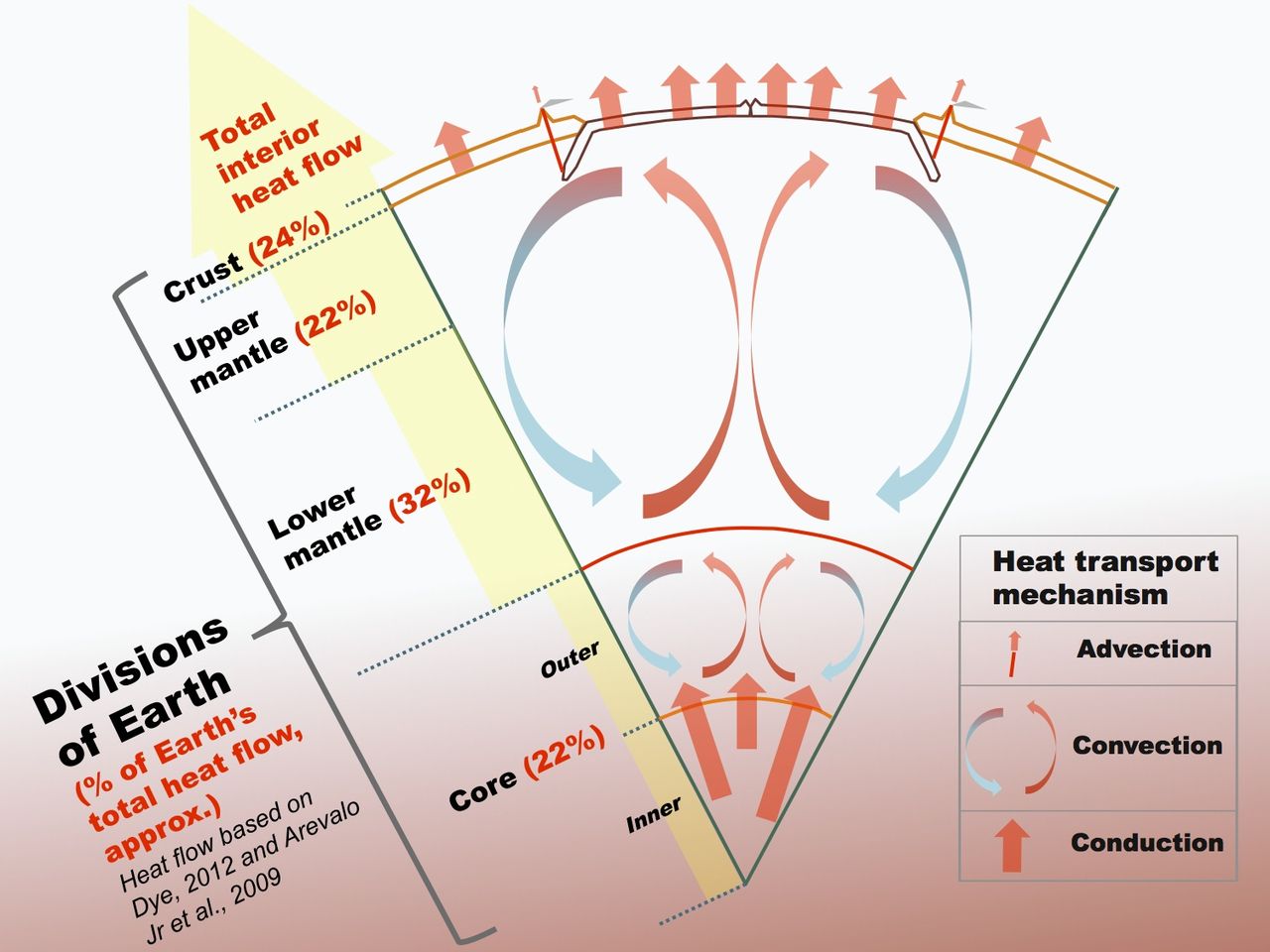
To start off, a quick tour: On average, the Earth’s radius is 6370 kilometers, but only the top 35 km is the crust (varying locally between 5 km at young sections of ocean and 70 km at old sections of continent). Underneath, the mantle stretches for over 2800 km to the boundary with the core.

|
| Kelvinsong, Wikimedia |
Below that, the core is composed largely1 of a 9:1 mix of iron and nickel, with around 3% lighter elements (mostly oxygen and sulfur, though possibly also a fair bit of hydrogen according to some recent research2). The outer core, stretching to 5150 km depth, is liquid in spite of the high pressure thanks to a temperature of 4000 to 5400 K (hotter with depth). Though the inner core is even hotter—as high as 6000 K—it is under even higher pressure, around 3,500,000 atm, such that it is forced back into a solid.
As mentioned in the last post, most new heat is generated in the mantle and crust by decaying radioactive isotopes, but the core retains a good deal of primordial heat and is the best-insulated part of the planet, so has the highest temperature. As it cools, iron from the liquid outer core crystallizes onto the surface of the inner core. The liquid just outside the inner core thus becomes iron-depleted and so lighter and more buoyant than the overlaying liquid. It rises to the core-mantle boundary and there loses its heat to the cooler mantle and gains back its iron by mixing with surrounding liquid, and so becomes less buoyant and sinks back down towards the inner core, thus forming a convection cell. The liquid metal is conductive, and so this motion—along with the Earth’s rotation—forms the planet’s magnetic field.
|
| "Advection" is transfer of heat by magma reaching the surface. Bkilli 1, Wikimedia. |
As this fresh rock is pushed further from the ridge, it cools and becomes denser, causing it to “float” lower on the underlying mantle, like a ship laden with cargo. This sinking helps to pull more material away from the ridge, and it’ll all move together as one tectonic plate. Eventually the rock will encounter another tectonic plate, and if that other plate is younger and less dense, then the rock will be pushed below it, forming a subduction zone. The rock sinks into the mantle, adding more pull to keep the rest of the plate behind it moving. It sinks lower, breaking up and mixing into the mantle as it goes, and eventually reaches the core-mantle boundary, closing the loop of mantle convection.

|
| Surachit, Wikimedia/USGS |
I’ve been emphasizing the pushing force from the mantle plume here to
keep a narrative thread, but in reality the relative importance of
“ridge-push” from mid-ocean ridges and “slab-pull” from
subduction zones is a long-running debate, with the current consensus
leaning towards the latter being far more important in most cases. I’ll
explain more in a moment, but the key point is that subduction causes
ridge spreading, not the latter, and in fact it also shapes the entire
pattern of the mantle convection cell. Heat from the interior forces the
mantle to convect, and would even if there was no tectonic motion on the
surface at all (we'll discuss the implications of that
next time), but the tectonic plates control where that convection happens.
If the original seam of lava bursting through the crust is underwater—as is usually the case—then the rock forming at the mid-ocean ridge will have some water mixed in with it. As it travels from mid-ocean ridge to subduction zone, it will also tend to accrue layers of sediment from material settling out of the water. These sediments will trap more water, and some—like carbonate minerals—will themselves be formed of other volatiles (carbon, hydrogen, sulfur, chlorine). As the plate subducts and warms up in the mantle, these volatiles will melt out of the rock and rise upwards, puncturing the overlaying plate and bursting through the surface as volcanoes. The volatiles themselves will mostly be released as gasses, but as they melt and rise, they bring some of the surrounding silicate rock with them. Heavy elements like iron will tend to sink out of the mix as it rises, and so once this magma reaches the surface, it will form iron-depleted felsic rock that is less dense than the mafic rock formed at mid-ocean ridges. Islands of this material will pile up on the overlaying plate along the subduction zone, forming an island arc.

|
|
This shows subduction-related volcanism along a continental
coastline, but it's essentially the same mechanism as for island
arcs.
KDS4444, Wikimedia |
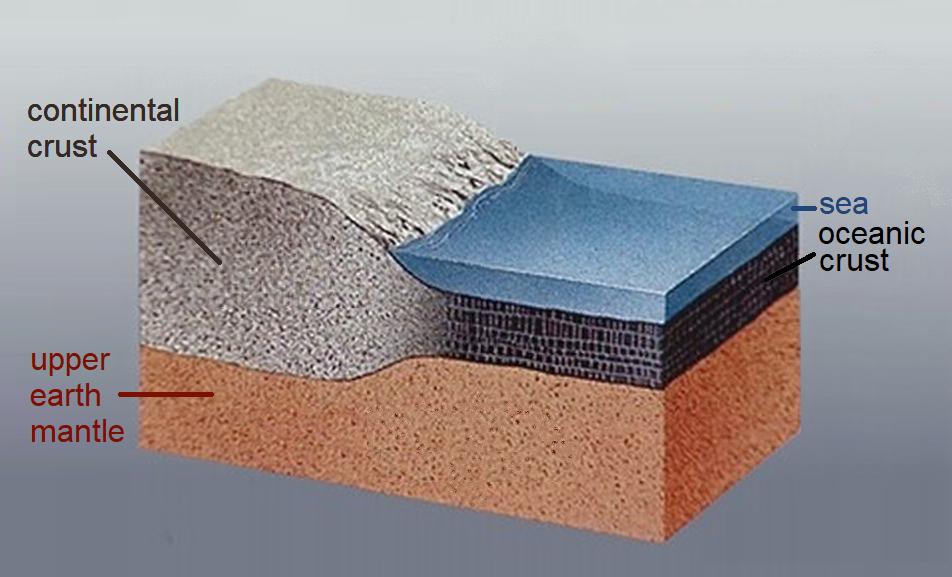
Given enough time, the individual volcanoes can produce enough rock to form a plate of their own; a section of continental crust, as opposed to the oceanic crust that forms at mid-ocean ridges. This lighter and thicker crust floats higher on the mantle, causing much of its surface to rise above the oceans.
|
| Note that continental crust extends further down into the mantle as well. USGS |
Once formed, continents grow by various mountain-forming events called
orogenies. When a continent encounters plates of oceanic
crust, the oceanic crust always subducts under the continental crust. As
it does, more subduction volcanism causes more rock to build up on the
continent along the plate boundary. If the oceanic plate already carries
some volcanic islands formed of felsic rock on it, these will collide
with the continent and fuse with it, forcing some of the rock to fold up
and form high mountain ranges.
Eventually subduction can pull two large continents together. They can continue to be pulled together for some time, pushing up a large plateau of folded rock, and one plate may even partially subduct under the other. But continental crust is too light to sink into the mantle, and so before long the plates will stop moving and fuse together. The thickened section of crust will be eroded from above and below, somewhat reducing the total amount of felsic rock (some rock is also pulled off the overlaying plate at subduction zones), but this is a far slower loss process than subduction and cannot destroy a continent completely, so continents are largely permanent once formed. Sections of the continents are billions of years old, while the oldest oceanic crust—in the eastern Mediterranean—is no more than 280 million years old, and most of the oceans are far younger.
Eventually subduction can pull two large continents together. They can continue to be pulled together for some time, pushing up a large plateau of folded rock, and one plate may even partially subduct under the other. But continental crust is too light to sink into the mantle, and so before long the plates will stop moving and fuse together. The thickened section of crust will be eroded from above and below, somewhat reducing the total amount of felsic rock (some rock is also pulled off the overlaying plate at subduction zones), but this is a far slower loss process than subduction and cannot destroy a continent completely, so continents are largely permanent once formed. Sections of the continents are billions of years old, while the oldest oceanic crust—in the eastern Mediterranean—is no more than 280 million years old, and most of the oceans are far younger.

|
| NOAA |
Thus, our modern planet is a patchwork of old continents and young oceans. Most of the tectonic plates contain sections of both types of crust, but the sections of oceanic crust are ephemeral attachments to the more persistent continental cores.

|
| Red dots indicate earthquake epicenters. Note that in the continent-continent case (right) the continental crust will not completely subduct |
Convergent
boundaries, where plates are moving towards each other. These can be
ocean-ocean subduction zones, such as the Marianas trench in the Eastern
Pacific forming the Marianas island arc; ocean-continent subduction
zones, such as the Peru-Chile trench off the western shore of South
America, forming the Andes mountain range; or continent-continent
collisions, such as the collision of India into Eurasia, forming the
Himalayan plateau. The subduction obviously pulls in the subducting
plate as the end is dragged down into the mountain, but there's also a
degree of suction pulling the overlaying plate towards the subducting
plate.
Exactly how subduction starts isn't fully understood, but once it gets
going, it may slow or temporarily stall, but it seems the only way to
stop subduction completely is a major collision between two continents;
smaller collisions will only cause temporary interruptions, as we'll
discuss in a bit more detail later.

|
| domdomegg, Wikimedia |
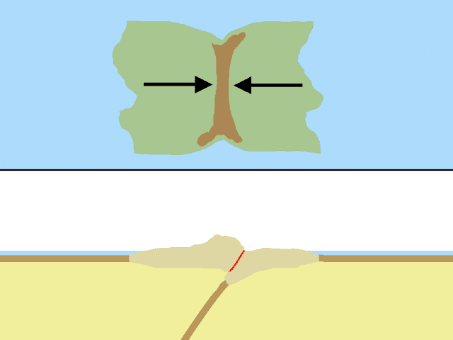
Divergent boundaries, where plates are spreading apart; mostly the mid-ocean ridges, such as in the Atlantic. But mantle plumes can also burst through continental crust, forcing the continent to spread apart and forming a rift valley, with volcanic ridgelines to either side (sometimes these plumes rise spontaneously on their own, sometimes continents are pulled apart by subduction zones and the mantle rises up to fill the gap). In fact, divergent boundaries almost always first form within continents, because despite being thicker than ocean crust, continental crust is also more brittle, and so will tear apart sooner under stress.
Before long, the continent is split apart, and a new ocean basin forms
with a mid-ocean ridge. At this point the divergent boundary is
essentially a passive feature; as subduction causes plates to pull
apart, hot rock from the mantle rises up to fill the gap, solidifying
onto the edges of the adjacent plates more-or-less symmetrically; the
boundary thus appears to "move" over time based on the relative motion
of the two plates (if, say, one plate is static while the other moves
west at 10 cm/year, the divergent boundary will drift west by 5 cm/year
due to this symmetrical plate growth). In addition to numerous mid-ocean
ridges in the modern ocean, East Africa is undergoing rifting, though
it’s unclear if this will ultimately split the continent apart or stall
out before that happens.

The key point here is that tectonic plates are not merely passengers
on mantle convection. In a broad abstract sense the thermodynamics of
the planet’s interior does provide the energy for plate motion, but
once the plates start moving it is they that dictate the motion of
rock through the mantle, not the other way around.
Extroversion


The rift zones will appear first as volcanically active rift valleys, but eventually split open into new ocean basins with mid-ocean ridges down their middles. Rifting often isn’t clean or simultaneous; Africa split from North America long before South America, and North America and Eurasia are still partially connected today over the Bering Strait.
But rifting can accelerate quite rapidly once underway, and this seems to be one of the few situations where outward pushing from the ridge significantly contributes to plate motion.


Flat-Slab Subduction

Subduction Jumping


Polarity Reversal


Rotation and Arc Formation


Subduction Invasion
As continents move apart during supercontinent rifting, gaps will
necessarily appear between them. The formation of island arcs as described
above will tend to fill these gaps, potentially forming a complete ring of
subduction dividing the interior and exterior ocean, as I showed for the
extroversion case. But this isn't always the case; sometimes instead
transverse boundaries can appear in these gaps, or the overall pattern of
motion can just be a bit more complicated than landmasses neatly moving
apart in a ring. This can allow for parts of the exterior ocean to start
subducting the interior ocean—"invading" it—in a couple different ways:


Triple-Junction Ocean Plate Formation


Continental Megashear


Other Considerations
The Delegation Approach

Transverse
boundaries, where plates are moving in different directions past
each other—or in the same direction but at different rates. Friction between
these plates can cause earthquakes and land deformation, such as
near the San Andreas fault in western North America, but no crust is
being formed or subducted, and there is no significant volcanism.
However, it's fairly common for predominantly convergent or
divergent boundaries to have small sections of transverse motion
within them, and even large portions of boundaries can switch back
and forth between transverse and their more typical motion.
In an idealized case such as the one I first described, a plate has a divergent boundary on one side and convergent on the other, such as is the case for the Nazca plate, forming a sort of conveyor belt of crust forming and then subducting at about the same. But this need not always be a case. The African plate is surrounding mostly by divergent boundaries, meaning it is growing on all sides, while the Filipino plate is surrounded mostly by convergent subduction zones and will be completely consumed before long. The total area of the plates must, of course, remain constant, but the different motions of all the plates can allow area to effectively be traded between plates that are not in contact (note, for example, how the western movement of the South American plate is shrinking the Nazca plate while also causing the African plate to grow, thus effectively transferring area from the former to the latter). Even where two plates are in contact, their complex shape or rotation of the plates can cause different types of boundaries to exist along the same border.
In an idealized case such as the one I first described, a plate has a divergent boundary on one side and convergent on the other, such as is the case for the Nazca plate, forming a sort of conveyor belt of crust forming and then subducting at about the same. But this need not always be a case. The African plate is surrounding mostly by divergent boundaries, meaning it is growing on all sides, while the Filipino plate is surrounded mostly by convergent subduction zones and will be completely consumed before long. The total area of the plates must, of course, remain constant, but the different motions of all the plates can allow area to effectively be traded between plates that are not in contact (note, for example, how the western movement of the South American plate is shrinking the Nazca plate while also causing the African plate to grow, thus effectively transferring area from the former to the latter). Even where two plates are in contact, their complex shape or rotation of the plates can cause different types of boundaries to exist along the same border.

|
| Major plates and the relative motion at their boundaries. USGS |
No one plate can get too large, though; the older the oceans, the
greater the chance they’ll subduct, and the larger the continent,
the greater the chance that it will rift apart.
Patterns of Plate Motion
Now that we have a handle on the basic mechanisms of plate tectonics, let's zoom out a bit and look at how these basic processes of subduction and rifting work out in terms of the motions of plates and continents. To be clear, a lot of the details of exactly how plate tectonics operates on a fundamental level and what patterns are possible are not fully known. Most of the established "rules" of plate tectonics3 are known based not on a full understanding of the mechanisms involved but simply what patterns we see in Earth's past, and that record is fairly murky; we have a fairly decent picture of the last 600 million years or so, but before that the geological record becomes fairly patchy and we're not even entirely sure when plate tectonics began (though as we'll discuss in the next post, it may have been a gradual transition through increasingly plate-tectonics-like regimes).
One consistent pattern we do see is the repeated appearance of
supercontinents, assemblages of all or most of the world's
major landmasses into a single large continent.
You've likely heard of the supercontinent Pangea 250 million
years ago, but before that was another supercontinent
Pannotia 600 million years ago, Rodinia about 1 billion
years ago, and Nuna 1.8 billion years ago, with some vague
hints in the geological record of another potential supercontinent
Kenorland 2.5 billion years ago.
Altogether this suggests a supercontinent cycle where the
continents rift apart and then join back together. The exact pacing depends on how you count Pannotia, which is somewhat the odd one out, never quite including all major continents and perhaps better to consider as just a late stage in Rodinia's breakup; if we exclude Pannotia, that implies a consistent 750-million year cycle, but if we include it and also consider that projections of Earth's
future tectonic motion4
generally predict assembly of a new supercontinent in about 200-250
million years, that may imply we've shifted from a slower cycle into a quicker 400-500 million
year supercontinent cycle. The other past few cycles for which we have detailed records are also not without their quirks: Rodinia started rifting apart before it was
fully assembled and
Pangea was continuously spalling off microcontinents from its eastern
coast all throughout its tenure.
But even if plate motion doesn't always neatly conform to an
ideal supercontinent cycle, it still provides a convenient framework
for constructing our own continents: Every continental world should be
in some stage of the breakup, assembly, or
tenure of a supercontinent, and it's generally easiest to start
designing a tectonic history during a supercontinent's tenure, when
there are the fewest pieces in motion.
Broadly speaking there seem to be two main types of
supercontinent cycle: extroversion, where continents
rift apart and then circle around the planet to collide back
together to form a new supercontinent on more-or-less the opposite
side of the world from the original supercontinent; and
introversion, where the continents move apart for a while,
but then reverse course and collide back together and form a new
superconinent about the same positions as the old
supercontinent.

|
| Earth in cross-section through different types of supercontinent cycles. Bradley 2011 |
Though the exact causes for one or the other cycle or supercontinent
cycles in general aren't totally clear, it may help to look at some
idealized examples of what these cycles look like and what features
continents will have throughout them.
Extroversion
Let's start there with a simple supercontinent, flanked by subduction
zones.

|
|
For these diagrams, the top area is a map with red, green, and
blue lines showing divergent, transverse, and convergent
boundaries (with "teeth" on subduction zones pointing to the
overlaying plate), arrows indicating plate motion, brown areas
indicating mountain formation, and maroon dots showing
volcanism; and the bottom area shows a not-to-scale
cross-section through the crust in the same area, with thicker,
lighter continental crust and thinner ocean crust. |
If there's a mid-ocean ridge in the ocean consistently forming new
ocean crust to feed into these subduction zones, this situation could
be quite stable, and indeed some past supercontinents seem to have sat
more-or-less in stasis for hundreds of millions of years (though this
may also reflect shifts in the nature of Earth's tectonics over time;
again, more on this in the next post). But a large
supercontinent insulates the mantle below it, and the trapped heat
causes plumes of hot rock to form that eventually rise and burst
through the surface in the form of hotspots—isolated
volcanoes—and flood volcanism—vast regions of volcanic
activity and lava flows (it’s
also possible5
the plumes have less to do with insulation and more with how
patterns of subduction around the supercontinent affect mantle
convection below it, but at any rate these plumes do consistently
form under supercontinents). These plumes do not themselves cause
rifting, but they form weak points in the crust which allows for
subductions zones outside the continent to pull it apart. They also
push the continental crust up slightly, creating a slight slope
between the supercontinent core and surrounding subduction zones
that the continents can slide down.

|
| Source |
New rifts usually form initially at a triple junction, where
initial tearing of the crust at a weak point spreads outwards in 3
directions.

Eventually the spreading rifts from neighboring triple junctions
join together into a single zig-zag shaped rift, which you can still
see in, for example, the overall shape of the modern Atlantic
coasts.

The third rifts from the triple junctions that don’t join with
others become failed rifts (also called aulacogens) and cease spreading, though they remain as weak points in the
crust and can be "reactivated" later if there's ever further
rifting. They also tend to erode easier than the surrounding crust
and so often become parts of later river valleys, or may even form
shallow inlets or ocean channels.

|
| Rifts formed in the Pangea breakup, which major associated rivers noted as well. Source. |
The rift zones will appear first as volcanically active rift valleys, but eventually split open into new ocean basins with mid-ocean ridges down their middles. Rifting often isn’t clean or simultaneous; Africa split from North America long before South America, and North America and Eurasia are still partially connected today over the Bering Strait.

But rifting can accelerate quite rapidly once underway, and this seems to be one of the few situations where outward pushing from the ridge significantly contributes to plate motion.

None of this is to say that large, supercontinent-induced mantle
plumes are required for rifting, incidentally—similar plumes might occasionally form under smaller continents, and
competing subduction zones can also pull a continent apart; as the crust
thins and tears, this will tend to encourage some upwelling of hot
mantle rock anyway—but it helps contribute to the particularly vigorous rifting of
supercontinents during breakup.
Anyway, at this point most continents will show a fairly typical
asymmetric profile, with modern South America being a good
example:

The coast facing the direction of motion, with the subduction zone,
forms an active margin, with a deep ocean trench just
offshore, a volcanic orogeny onshore that pushes up a high mountain
range, and a steep coastline between them. The leeward coast forms a
passive margin, with well-eroded topography, vast coastal
plains, and wide continental shelves (though as we'll note later,
it's common for there to be some old eroded mountains there as
well).
Though I'm mostly keeping to linear motion with two continents in
my examples here for simplicity, more typically you'll often have
several continents rifting away in all directions, forming a ring of
landmasses and island arcs dividing a young, expanding
interior ocean surrounded by passive margins from an older,
shrinking exterior ocean surrounded by active margins.

But of course reality is rarely so neat; you may have some
continents like Africa surrounded by passive margins that are
essentially "left behind" in the interior; you may have precocious
continents that rift away from the supercontinent early—or never joined it at all—and so end up isolated in the exterior ocean; and as we'll discuss
new subduction zones may form in the interior ocean, forming more
complex patterns.
But returning to our simple case, these continents can only move
apart so far; as the exterior ocean shrinks, eventually the
continents will circle around the planet and meet up again on the
far side.

How long the exterior ocean survives often depends on the state of
the mid-ocean ridges within it. A situation like we see here, with a
central mid-ocean ridge feeding ocean crust directly into
surrounding subduction zones, can be quite stable, with the
surrounding continents moving slowly or perhaps even stalling out
entirely. But in many cases there's likely to be some slight
mismatch in the speed of ocean crust subduction or continental
motion, which will cause the mid-ocean rift to drift towards one
side or the other, until it eventually subducts.

At this point there's no new crust forming to accomodate the
subduction around the edges of the exterior ocean. It's not
impossible for new rifting to start in the ocean—a new divergent boundary appears to be currently forming in the Indian
ocean as India and Australia are being pulled in different
directions—but more typically the competing pull of the continents on the same
plate will cause them to be pulled together, ultimately closing the
former exterior ocean as the last of its crust is subducted and the
continents collide.

I've set up a very symmetrical collision here, but of course real
collisions will vary and the exact details of how different sections of
crust move about in the final stages of collision can be quite complex,
but what typically ultimately happens is that one continent partially
subducts under the other. As the two continents push into each other, a
tall mountain range is pushed up between them, but volcanic activity
stops without a supply of volatiles from subducting ocean crust.

The buoyancy of the continental crust prevents it from sinking more
than a couple hundred km into the mantle, so eventually subduction
finally stops (and the already subducted ocean crust detaches from the
continent and sinks into the mantle). The two continents
suture together, forming a single landmass with a common plate
that will now move as one, but fractures and faults formed during the
collision will remain as weaknesses where new rifts may form if the
continent is ever pulled apart again, and even without fully rifting
plates often aren't completely rigid and can have a bit of internal
sliding and stretching long after collisions.
The mountain range also remains, and will gradually erode down over
millions of years. This is a point worth emphasizing because it's often
missed in more simplistic approaches to mapping with tectonics: not all
mountain ranges are associated with current tectonic boundaries. All of
Earth's continents have remnants of mountains formed in past collisions
that are far from any plate boundaries and have long since stopped
seeing any significant relative motion.
At any rate, in our simple 2-continent world, that completes a
supercontinent extroversion cycle: areas that were once the interior of
the old supercontinent are now on the coasts, and the old coastlines are
now mostly trapped in the interior.
Introversion
Let's follow our recently-formed supercontinent through another
supercontinent cycle. For new rifting to start, we need new subduction
to start, but we don't fully understand how this actually happens. As
the ocean crust around the edges of the continent's passive margin ages,
it will become denser and less buoyant, but also stiffens, so some
additional process is needed to fracture the crust.
Broadly speaking6
there are three concepts for how this occurs (excluding cases we'll
discuss in a bit where one subduction zone induces formation of
another), all of which might happen in different cases:

|
|
We'll discuss the induced cases later.
Stern and Gerya 2018 |
-
Passive margin collapse: In some cases the ocean crust may
break away from the continental crust and start subducting
directly along the coastline, but this seems to be quite rare and
may require preexisting faults from previous tectonic stresses.
- Transform collapse: Probably the most common mechanism; where there is a transform fault between two sections of crust of different age, the older side may eventually sink and subduct under the other. This may happen at plate transverse boundaries, but smaller transform faults inevitably form in growing oceans as different sections of the divergent boundary spread at different rates; the geometry of plate motion over a spherical surface makes these faults inevitable, so they can expected to be present in every ocean.
-
Plume head margin collapse: Large plumes of upwelling hot
rock around young hotspots may push up some crust while tugging
down on crust around the plume, eventually starting subduction
around its edges.
Once subduction starts, the subducting slab will pull on the crust
around it, fracturing the crust or stressing preexisting faults, such
that the subduction zone spreads outwards. Some researchers even suggest
that formation of wholly new subduction zones from scratch is rare, and
instead new subduction zones mostly form by spreading out of old
zones.

Regardless, subduction seems to be more likely as the ocean crust
ages, and in the time it's taken for our continents to circle the
planet, the adjacent crust must have gotten pretty old, so new
subduction zones will likely appear around the coasts eventually,
turning the former passive margins into new active margins.

We're now in essentially the same situation we started with in the
first supercontinent cyle, so we can rift the supercontinent apart
again and get going. New rifts between continents often form close
to where they previously sutured together, but generally not along
the exact same lines, so as continents join and then rift back
apart, there's essentially always some exchange of landmass between
them.

As I alluded to earlier, this tends to place the old mountains
formed in assembly of the supercontinent along the passive margin of
this new continent, while new mountains form along the active
margin. These older mountains will be significantly eroded down by
now and will have wider coastal plains between them and the sea than
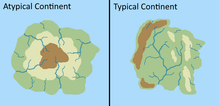
the newer mountains, but it's still worth noting that, contrary to
the common tendency of many inexperienced mappers and simplistic map
generators to make continents with high interiors sloping down to
low coasts, the more common (but not ubiquitous) tendency is for
continents to have low interior basins surrounded by coastal
mountain ranges of various ages. This also incidentally helps form
large river basins like the Amazon or Mississippi, as these large
interior basins have to drain out through the few gaps between
mountain ranges.
Anyway, as the continents spread apart, what was the interior ocean
of the last supercontinent cycle becomes the exterior ocean of this
one, and a new interior ocean forms between them. If we did another
extroversion cycle, we could keep endlessly bouncing these
continents between either side of the world. But this time, let's
imagine that a new subduction zone forms a bit quicker within the
interior ocean before a new supercontinent forms.

The interior ocean is now being subducted on only one side, so the
mid-ocean ridge quickly subducts into the new subduction zone. The
eastern continent here is then directly subducting the plate of the
western continent, pulling them back together (presuming the
exterior ocean still has mid-ocean ridges that can feed new ocean
crust into the outside subduction zones; if not, this would likely
cause the western continent to rift in two, with one half continuing
west into the exterior ocean and the other half heading east).
Naturally this eventually leads to a collision, likely a somewhat
more vigorous one with one continent directly subducting the other.
The continents likely won't collide back together along the same
line they rifted along, but nevertheless the interior of the old
supercontinent is mostly the interior of the new supercontinent, the
coasts remain the coasts, and the exterior ocean survives while the
interior ocean closes.

Even aside from global introversion cycles, this process of
rifting, spreading, forming a new interior subduction zone, and
colliding back together, called a Wilson cycle, is also
fairly common at smaller scales (and even a pair of extroversion
cycles can be considered a long Wilson cycle). Parts of modern North
America and Europe have collided and rifted apart twice over the
last couple billion years, and several projections of future
tectonic motion predict they may be on course for a third
collision.

To a certain extent, supercontinent cycles may just be an
inevitable result of the geometry of plate motion and tendencies of
the processes involved: aging oceans will prompt the formation of
new subduction zones, which will pull continents together, and so
long as continents suture together faster than they rift apart—which generally seems to be the case except in the early stages of
supercontinent breakup, when the new continents are all moving apart
into a large exterior ocean—they will inevitably join into a single supercontinent
eventually.
But convection of the mantle may also play a role: upwelling of the
mantle pushes the crust slightly up, around the position of the former
supercontinent, and downwelling in the mantle elsewhere may pull the
mantle slightly downwards. Though the geometry of subduction zones and
other plate boundaries still determines the exact movement of plates
(and may influence where downwelling occurs), this subtle gradient in
the crust may help bias their motion enough to encourage supercontinent
assembly. Shifts in mantle convection may help influence whether an
extroversion or introversion cycle occurs, but it may also come down to
chance and circumstance in terms of how quickly new subduction zones
form in the interior ocean and how long mid-ocean ridges survive in
either ocean.
But really any particular supercontinent cycle will tend to have
versions of both7
cycles in separate ocean basins, and some researchers also
distinguish a third in-between pattern, orthoversion, where
continents do a sort of half-turn before colliding somewhere between
their starting point and the opposite side of the world without
fully closing either interior or exterior ocean.

Of the last several cycles, Nuna to Rodinia was probably mostly an
extroversion cycle but many of the details are still unclear;
Rodinia to Pannotia might be counted as either an extroversion or
orthoversion cycle; and Pannotia to Pangea was largely introversion
but again with elements of orthoversion.
Competing models of future tectonic motion largely come down to
different predictions of the nature of the current supercontinent
cycle: the Novopangea model predicts continued extroversion,
closing the Pacific; the Pangea Ultima model predicts
introversion, closing the Atlantic; the Amasia model predicts
orthoversion, with continents mostly shifting north and closing the
Arctic; and the Aurica model predicts a mix of introversion
and extroversion, with both the Atlantic and Pacific closing and
Eurasia rifting apart to form a new ocean.

|
|
White lines indicate divergent zones and thick black lines
along coasts show subduction zones.
Davies et al. 2018 |
At any rate, now that we've got a broad sense of the most common
patterns of global tectonic motion, I'd like to go over a few more
unusual cases we might encounter on more local scales. I can't
predict every eventuality that might turn up, but
the essential rule to keep in mind throughout is that, again,
subduction is active and rifting and ridge spreading is
passive. Subduction zones dictate the movement of plates, though
the relative importance of different subduction zones seems to depend on
mantle processes that aren’t fully understood. The best interpretation
right now is that mantle convection forces the supercontinent cycle to
occur, but subduction determines all the details.
Flat-Slab Subduction
Usually the mountain range along an active margin is fairly
narrow and steep, such that it might almost appear as a sheer wall
on the continent's coastline in large maps, but in some
cases a continent may experience flat-slab subduction, where a
subducting plate doesn’t immediately dive into the mantle but
slides underneath the continent for some distance before finally
turning downwards.

This causes uplift and deformation far into the interior of the
continent, forming a much broader mountain range, and volcanic
activity either shifts further inland or may stop entirely. Even
inland of the mountain range itself, much of the continent's
interior may be uplifted. This is partially how the Rockies in
North America formed, pushing up much of the continent in the
process to form the gradient across much of the interior, and more
recent flat-slab subduction has contributed to some of the broader
sections of the Andes in South America.
Exactly why this happens isn't totally clear, though there are
two main proposals: first, that it's caused by (relatively)
rapid motion of the continent8 towards the subduction zone, such that it's essentially
overrunning the subduction zone and ocean crust behind it faster
than it can subduct; second, that it's caused by subduction of
young crust too buoyant to subduct normally, or even
subduction of a mid-ocean ridge9, which in particular can leave open a "window" in the subducting
ocean crust through which hot mantle rock can rise and push up the
continent.
Island Arc Accretion


|
| EOS.org, modified from Finzel et al. 2016. |
For the most part this doesn't change much about the continent's
motion, but in North America's case, subduction of mid-ocean ridges
and so breaking of the subducting slabs—though also the somewhat oblique relative motion of the North
American and Pacific plates—also seems to have caused subduction to stall out, with only
transverse motion on much of the west coast, but this is probably
temporary and subduction will resume here eventually; though whether
this is necessarily always the case when mid-ocean ridges are
subducted is not fully settled.
Slab Rollback
Converse to the rapid motion that may cause flat-slab
subduction, this is caused by
slow subduction, with ocean crust being subducted slower than
it is produced. This means that the age of the ocean crust at
the time it subducts is increasing over time. Thus the
subducting crust is becoming progressively denser and less
buoyant, and so it tends to sink quicker and steeper into the
mantle. This produces a degree of suction on the overlaying
plate, pulling it towards the subducting plate.
The general result is that parts of the coastline tear away from the continent and migrate out to sea with the subduction zone. Volcanism and uplift still continue along the subduction zone, forming an offshore island arc. Behind this arc, the continental crust is stretched and thinned out, forming a back-arc basin. (though note that "back-arc basin" is sometimes also used to refer to the interior lowlands behind more regular coastal orogenies as well).


|
| Niu 2014 |
The general result is that parts of the coastline tear away from the continent and migrate out to sea with the subduction zone. Volcanism and uplift still continue along the subduction zone, forming an offshore island arc. Behind this arc, the continental crust is stretched and thinned out, forming a back-arc basin. (though note that "back-arc basin" is sometimes also used to refer to the interior lowlands behind more regular coastal orogenies as well).

Fractures in the crust turn into hotspots, forming more
volcanic islands. New oceanic crust can even form in the
basin, but there is no mid-ocean ridge and the basin won't
ever open up into a new ocean.
This situation might arise whenever a continent has
subduction zones on opposite coasts, such as during an
introversion cycle—when a new subduction forms on the interior ocean side but the
old subduction zone is still active on the exterior ocean
side—or in the later parts of an extroversion cycle if new subduction
zones start forming around the interior ocean before the
continents have collided. As the continent moves, the leading edge
will have a regular active margin with a coastal range, but the
trailing edge will be pulled away from the mid-ocean ridge feeding
it ocean crust, and so tend to experience slab rollback.

But slab rollback can also emerge in other cases of slow
continent motion or restricted ocean crust motion. The east
coast of asia is experiencing slab rollback today due to the
slow motion of Eurasia and eastward shift of mid-ocean ridges
in the Pacific ocean, forming an offshore island arc in the
form of Japan and the neighboring Kuril and Ryuku
islands.
If the continent’s motion shifts such that slab rollback
stops (e.g. if it reverses course or collides with another
continent on its leading edge) the subduction zone and island
arc will be pushed back into the mainland and transition into
a more typical active margin, though a fair bit of ocean crust
from the back-arc basin may be scooped onto the continent in
the process, which may contain some resources like chromium
that are relatively rare in continental crust.
Island Arc Accretion
When new subduction zones form along a continent coastline,
they need not form exactly on the coast; though they typically
start near the coast, they may arc out into the ocean as they
spread along preexisting faults and weaknesses. They'll then
form a new island arc that can reach far out to sea.

|
|
Again, arcs are usually connected to continents at one end
or the other, this is just a conceptual diagram. |
But the ocean crust between the island arc and continent will
continue to age, so sooner or later another subduction zone is
likely to form, particularly if the continent starts moving in
the direction of the island arc. This naturally pulls the island
arc into a collision with the continent.

The new continental crust formed in the island arc will join
the continent, pushing up collision mountain ranges as it does.
Subduction continues on the new continental coastline, such that
the combined collision and continued coastal volcanism forms a
single broad coastal mountain range.

This tendency to form offshore island arcs which then get
pulled in to accrete onto the continent is a fairly
common way continents grow over time, to the point that a large
portion of modern continental crust first formed as island arcs.
North America has recently accreted several island arcs along
its west coast (which is another contributing factor to the
broad mountain ranges there), and Asia is in the early stages of
accreting the Philippines and Marianas arcs.
But while we're at it, there are some slightly more complicated cases
of accretion worth mentioning as well:
Subduction Jumping
In this case, imagine that rather than an island arc with its own
subduction zone, a continent is pulling in a microcontinent, a
smallish landmass that has rifted off some other continent.

The continent and microcontinent will collide, closing the subduction
zone and forming a collisional mountain range. However, if the
microcontinent is fairly thin, subduction may not stop at this point:
instead, the subduction zone will "jump" across the continent, starting
up on the new coastline. As with much of the mechanisms of subduction,
the exact details of how this occurs aren't fully understood, but it
seems the stress of the collision may cause the ocean crust to fracture
behind the microcontinent, allowing it to subduct.

This can also happen with oceanic plateaus (thick sections of ocean
crust formed by seafloor volcanism), with the result that subduction
effectively moves offshore, but the plateau will likely be pushed up
into the continent eventually.
Polarity Reversal
In this case, imagine that there initially is no subduction on the
continent's coast, and instead an island arc or microcontinent is
subducting the ocean crust attached to the continent.

As per usual, this eventually results in a collision. But as in the
last case, subduction likely won't stop: the stress of collision
fractures the crust behind the arc, and new subduction starts on the
continent's new coastline. The oddity here is that subduction switches
direction, so that what was once the subducting plate now becomes the
overlaying plate.

You can also imagine a final scenario where an island arc and continent
(or a second island arc) are both subducting a small ocean plate between
them.

Exactly how this plays out can vary, but ultimately with the same end
result: the two landmasses collide and subduction continues on the new
coastline of the continent.
Subduction jumping and polarity reversal can also occur when island
arcs or microcontinents collide, though which will occur in which
circumstance can vary; in general the side with older ocean crust is
more likely to subduct, but this isn't a universal rule.
The prevalence of these mechanisms means that essentially the only way
to permanently stop a subduction zone is with a major collision between
two large continents. The degree to which this is always strictly true
for every case is debateable, but in broad terms when thinking of
tectonic motion over hundreds of millions of years, it's a decent rule
to follow.
Rotation and Arc Formation
I've already alluded to this a couple times, but it's worth
highlighting explicitly: long ocean island arcs might also form
progressively as two landmasses rift apart. If their rift cuts through a
subduction zone, rather than splitting apart, the subduction zone will
often tend to grow with the new ocean, bridging the two
continents:

The geometry of motion on a spherical surface means plates can't move
perfectly apart, and indeed the more common tendency is for a more
hinge-like motion due uneven forces. This rotational motion is part of
why subduction zones and island chains so often have their
characteristic arc shape; on a flat world with plate tectonics, tectonic
boundaries and island chains would tend to be straighter.

These island arcs can become quite long and stretch far from the
continent, but because subduction usually starts near coastlines, you
shouldn't expect to see island arcs completely isolated in the middle of
the ocean.
Subduction Invasion
As continents move apart during supercontinent rifting, gaps will
necessarily appear between them. The formation of island arcs as described
above will tend to fill these gaps, potentially forming a complete ring of
subduction dividing the interior and exterior ocean, as I showed for the
extroversion case. But this isn't always the case; sometimes instead
transverse boundaries can appear in these gaps, or the overall pattern of
motion can just be a bit more complicated than landmasses neatly moving
apart in a ring. This can allow for parts of the exterior ocean to start
subducting the interior ocean—"invading" it—in a couple different ways:
First, a transverse boundary separating the oceans might develop into a
subduction zone by transform collapse. Usually the interior ocean will
tend to have younger crust than the exterior ocean, and so this new
subduction zone will subduct the exterior ocean, but this may not always
be the case if new crust is still forming in the exterior ocean.

Second, a landmass in the exterior ocean may collide with one of the
subduction zones. This may be a large continent that rifted away from the
supercontinent early and has since reversed course, but even a small
landmass could trigger polarity reversal.

In either case, this new subduction zone could start rapidly expanding
into the interior ocean, and may spread to the coasts of nearby
continents. Indeed, subduction invasion events may be a major element of
what causes introversion cycles (though it's hard to tell because they can
be difficult to reconstruct from geological evidence).

Subduction invasion from the Pacific into the Atlantic is currently
underway around the Caribbean and Scotia seas, which is what leads some
researchers
to suggest we're bound for an introversion cycle.
Triple-Junction Ocean Plate Formation
For this case, consider an ocean composed of three plates all diverging
from each other, forming three mid-ocean ridges. For simplicity's sake
we might imagine this as an exterior ocean surrounded by subduction
zones, but that doesn't necessarily have to be the case. If it is an
exterior ocean, then this is a fairly stable configuration so long as
all the ocean plates are diverging at about the same pace.

Where the mid-ocean ridges intersect at a triple junction, new ocean
crust will usually form on all three sides, attached to the existing
plates. However, if the plates are not all moving directly apart but
instead rotating around the triple junction to some extent, this
twisting motion might cause a gap to open at the triple junction (the
exact geometry is a bit tricky to explain and involves some extra
elements like a short-lived subduction zone, so I refer you to
this paper10 for details).

Mantle rock will rise to fill the gap, forming new ocean crust, but it
may not be attached to any of the existing plates, and so will form its
own new ocean plate. As the surrounding ocean plates continue to move
away, new mid-ocean ridges will form around this new section of crust,
adding more crust to its sides and causing it to grow. The old plates,
meanwhile, continue to subduct at the ocean's edges. This asymmetric
motion—the new plate remaining relatively still while the old plates move
towards the subduction zones—causes the mid-ocean ridges to also drift out towards the edges of the
ocean.

Eventually the old plates will subduct completely, along with the
mid-ocean ridges. This may leave the ocean with no source of new ocean
crust and so force the surrounding subduction zones to converge. So the
formation of a new ocean plate like this can destabilize a previous
stable ocean basin and force its closure.
This is generally believed to be how the Pacific ocean formed, though
without much data on ocean plate motion older than around 200 million
years ago, we can't say much about how common it is in general. In the
Pacific's case, most of the surrounding plates have subducted, but one
still survives in the Nazca and Cocos plates to its southeast, which
could conceivably allow the ocean to survive if the Pacific plate
starts moving quicker to the west and the mid-ocean ridge shifts
towards the ocean's center.
(I had trouble finding a good animation of this one, but this one is
fairly decent for at least the early stages; pay attention to the left
side of the map).
Continental Megashear
This is a slightly tricky one but I thought it could be worth
mentioning: Some ambiguities in the geological record (specifically,
paleomagnetic data from Australia that doesn't neatly match up with
typical reconstructions of Pangea's formation) have led
some researchers to suggest11
that Pangea initially formed in a different configuration, "Pangea B",
with much of the northern part of the supercontinent farther west than
typically reconstructed. The two halves of the supercontinent would
then have slid into their more familiar "Pangea A" configuration over
20 million years along one enormous 6,000-km-long transverse boundary,
sometimes called a megashear system.

This model has never gained wide acceptance, with
recent studies12
finding more evidence to support the conventional reconstructions and
alternate explanations for the anomalous data. However, as far as I
can tell, these studies don't seem to question the basic plausibility
of such a megashear event in principle, just it's occurence in this
particular case. This may just be due to our uncertainties about the
mechanisms of plate tectonics, and if we discard the Pangea B model
that doesn't leave us with any other clear examples from Earth's past
to go by (though smaller shear events are fairly common), but at any
rate a megashear scenario is perhaps still worth considering as a
possibility if the configuration of subduction zones favors it.
Tethys-Type Oceans


Complex Collisions
Finally, the examples I've given for landmass collisions have all
been fairly straightforward, with straight boundaries, but this may of
course not always be the case. If two continents with more complex
coastlines converge, some areas may start colliding while others are
still divided by sections of ocean.
Tethys-Type Oceans
Our last two cases are essentially just combinations of several of
the mechanisms we've discussed, but worth working through as
examples. In this case, imagine a large, arc-shaped continent has
subduction along part of the inside face of that arc, which might
happen due to a collision that only closes part of a subduction
zone, or just the appearance of new subduction on the coast of a
preexisting continent.

In this case, the subduction zone in the west is directly pulling
on the land on the east side of the sea, but because they're
connected by the arc of the continent they can't directly collide
together. This could perhaps lead to a megathrust scenario as
described above, but more typically the result is that part of the
continent on the sea's eastern coast tears away (because as
mentioned, continental crust is more brittle and will tear before
ocean crust) and moves west to collide with the island arc.

If this is a fairly small microcontinent, then subduction will jump
across it and carry on. There's now a mid-ocean ridge in the sea, but as we saw with the
later stages of introversion, subduction on one side of the ocean
will eventually consume the mid-ocean ridge, bringing us essentially
back around to where we started.

Stopping the subduction zone for good requires a large continent to
break away (or enter the situation from elsewhere) and collide with
the subducting shore. As per usual, this forms a collisional
mountain range. But if one of the continents has recently had
several collisions with microcontinents or island arcs (which
doesn't necessarily require this particular Tethys-type setup), that
will leave numerous weaknesses and faults which may begin to shift
again in this collision. Combined with the fairly rapid collision
that tends to result from one-sided subduction like this, that can
cause a particularly broad and complex mountain plateau to
form.

As the name implies, the classic example of this is the Tethys
ocean to the East of Pangea, which had a subduction zone along its
northern boundary, which progressively pulled in several
microcontinents from the southern regions of Pangea before finally
pulling in India and forming the Tibetan plateau (I couldn't find a
good video of this whole process specifically, but you can see it if
you scroll back up to the global tectonics video and pay attention
to the ocean to Pangea's east from about 400 million years ago
onwards).
Complex Collisions
Finally, the examples I've given for landmass collisions have all
been fairly straightforward, with straight boundaries, but this may of
course not always be the case. If two continents with more complex
coastlines converge, some areas may start colliding while others are
still divided by sections of ocean.

What happens then can be quite complex, as the collisions cause
different sections of crust to fracture and shift, and the small
isolated subduction zones can tear off pieces of crust around them,
undergo slab rollback, or invade neighboring sections of ocean. One
particular curious pattern is the potential for slab rollback and
back-arc spreading in these small spaces to allow a subduction zone to
move forward into collision with another landmass, rather than pulling
a landmass in to collide with it. Stretching of the crust and hotspot
activity can form numerous islands in the back-arc basin.

The Mediterranean is the classic example of this, representing the
early stages of a collision between Africa and Eurasia, with local
subduction and collision forming its mix of islands, peninsulas, and
ridgelines, with slab rollback in the Tyrrhenian, Aegian, and
Levantine seas and the Pannonian basin.
(Note that the start of this video moves back in time)from the
present day, then forward again in the latter half.)
Other Considerations
Plate speed
depends on a couple different factors. Subducting plates move
fastest due to slab pull, and subduction even helps pull
overlaying plates through slab suction. Ridge push has
a secondary effect, which is stronger for plates spreading away from
a former supercontinent thanks to the slight slope created by mantle
plumes—but to be clear, a continent can only be moved by ridge push
if there is subduction elsewhere helping it along. Countering these
forces is drag from the mantle, which has a stronger effect on
continents because they have deeper lithospheric “roots”. As points
of reference:
- India, on a mostly-oceanic subducting plate, topped out at 20 centimeters/year in the late Cretaceous, and even after colliding with Asia is still moving north at around 6 cm/yr.
- The Nazca plate, a subducting oceanic plate, is moving east13 at 10 cm/yr, and the Pacific plate west at around 8 cm/yr.
- North and South America, large continents with large active margins, are both moving west at 3 cm/yr.
- When it initially starting rifting from Africa, North America only moved at 1 cm/yr for the first 25 million years, before abruptly accelerating14 to 3.5 cm/yr in a 6-million-year-window.
- Eurasia, a huge continent with a small active margin, is only moving about 1.5 cm/yr. Despite being a “convergent” boundary, the eastern coast is actually spreading at 1-2 cm/yr to accommodate the motion of the Americas (which is to say, oceanic crust is still subducting but the boundary is moving away from the mid-ocean ridge), which is causing slab rollback and back-arc extension.
- Africa and Antarctica, continents surrounded by divergent boundaries, both move at less than 1 cm/yr.
So as general guidelines:
|
Situation
|
Subducting Ocean
|
Recent Subduction Collision
|
Active Margin Continent
|
Passive Margin Continent
|
|
Plate speed (cm/year)
|
10-20
|
5-10
|
2-5
|
<1
|
1 cm/yr is about 0.9° of rotation around the Earth every 10 million
years (i.e. 0.9° latitude or longitude on the equator), so as a
convenient rule of thumb you might say that an active margin
continent moving west on the equator for 100 million years should
tend to cover about 20-50°
longitude. For planets of other sizes, you should divide that
conversion factor by the planet's radius in Earth radii; but whether or not we should expect planets of
different size or even different age to have similar plate speeds is a
largely unresolved question.
There
appears to have been15
a general increase in average plate speed since the onset of plate
tectonics, roughly doubling over the last 2 billion years, which may be associated with the period of the supercontinent cycle
decreasing by the same factor, but at any one time overall variation
will be larger than this general trend. Plates can accelerate very
quickly when a new subduction zone is formed or a mid-ocean ridge is
subducted.
Note that the speed of a plate’s movement is not necessarily the speed
at which it’s boundaries are moving, save for in the case of a
continent’s leading-edge active margin; an ocean plate can be moving
at high speed but bounded by static convergent and divergent margins
(though no boundary is totally still today).
The area of the continents appears to have generally
increased over time, though exactly how quickly and whether it's
continuing to grow
remains unclear16. Today, it appears that the Earth is gaining
an average17
of 0.6-0.9 cubic kilometers of continental crust per year—at an average thickness of 35 km, that’s 0.017-0.025
km2/year, or 17-26 thousand km2/million years,
compared to a current continental crust area (including submerged
continental shelves) of ~200 million km2. That’s around
9-15% growth over the last billion years; not a lot, but worth
bearing in mind (all of this assuming average continental crust
thickness has remained constant, which might not be the case). This
may go faster on larger planets because of square-cube scaling
between the area of the crust and the volume of the mantle, but it's
not clear.
Finally, sea levels tend to rise and fall relative to the
continents with the supercontinent cycle. During a supercontinent’s
tenure, the oceans are mostly composed of old, low-lying oceanic crust
and the continents are lifted up by mantle plumes, combining to cause
low sea levels. Once the continent breaks up, the old oceanic crust is
replaced with younger, more buoyant crust, reducing the volume of the
oceans, and the continents move off the mantle plumes and so sink
slightly, so sea levels rise over the next hundred million years or
so, until the oceanic crust ages and continents begin reassembling.
Global climate and glaciations also affect sea level, but the
relationship of those to tectonic events is harder to parse; we’ll
tackle that in a later post.
Simulating Plate Tectonics
To get a map with a realistic tectonic history, there’s a few different approaches to consider, all of which involve creating a new map. I don’t suggest trying to retcon a tectonic history onto a map you’ve already made—sorry—for much the same reason I would suggest tossing out a set of pool balls onto a table and then trying to devise a pool game that would arrive at that state. I also don't suggest trying to just slap down plate boundaries at random and then draw continents to fit them; most attempts I've seen of that create plate boundary patterns that simply could never plausibly arise in reality, and in general continents are not passive passengers on plates, they play a key role in deciding how plate boundaries develop and where plates move.
The Delegation Approach
Most map generators simply aren't very good at replicating the features
of plate tectonics, relying on fractal generation algorithms that
produce terrain that may vaguely resemble real coastlines and mountains
at a glance but doesn't stand up to any real scrutiny. Rather than a diverse world, you end up with pretty much the same
ragged coasts, rolling hills, and gently rising highlands everywhere on
the planet.
As it stands, the only full map generator I've seen with a decent
implementation of plate tectonics is that in the alpha version of
Songs of the Eons, a strategy game in development. It doesn't perfectly replicate all
the features that emerge from plate tectonics (sadly it lacks
fold-and-thrust belts, probably due to resolution limitations) but it
pretty reliably produces a reasonable distribution of plate boundaries
and associated mountain features, and even simulates glacial action to
an extent.
The Quick and Dirty Approach
Break apart the fragments a bit, rotate them, maybe crash a couple of
them into each other, and we should be good.
For introversion, we place subduction zones in the interior ocean, but turn them into leading-edge active margins and leave the exterior coasts as trailing-edge active margins (this needn’t happen on all sides of the ocean, just one will do). Carry the continents back towards each other, but with some rotation as they’re pulled about by the new subduction zones; the coasts shouldn’t meet back up neatly in the same places they split
If we want a supercontinent, we just carry forward either case until the continents have all met back up and closed the oceans between them, leaving high mountain ranges along the sutures and active margins on most—or all—of the coasts. The supercontinent should still be moving somewhat relative to the oceans, so we’ll have a leading edge and trailing edge, and we can also have microcontinents moving around the edges if we don’t want all the land area in one piece.
The Obsessively Detailed Approach
From here I'll move forward in 50-million-year steps, moving the continents, creating new oceans, and splitting and fusing plates as required by the rules laid out so far—though still with some space for artistic interpretation in the exact speed and direction of plate movement and placement of new rifts. Though we haven't marked out any boundaries in the oceans, we only need a few subduction zones to start out with and before long we'll have completely replaced the old oceans with new crust.


The two supercontinent halves—ABCDEF and GHIJ—drift apart, leaving a mid-ocean ridge between them (marked in red, like the rifts) and transform boundaries on their edges (marked in green). New ocean crust forms between them (shaded in lighter blue than the Pre-Cuvieric ocean crust). They do not break apart evenly—on such a long border on a spherical planet that’s not really possible, but in this case especially the subduction zone on GHIJ’s north shore helps rotate the continents as they split.

The continents continue to drift apart, and now a triple-junction of
mid-ocean ridges has formed between them. I’ll add one more rift to
split ABCD from EF—again along a prior failed rift—and call it good so
far as the primary supercontinent breakup is concerned.


Microcontinent 5 impacts E, sandwiching some island arcs, and other island arcs from ocean i impact E’s south coast, creating a long, complex orogeny. The subduction zone jumps across plate 5, and E is pulled towards a collision with the supercontinent.


And indeed we can pretty well see a supercontinent cycle of breakup (Cuvieric, Anningic), assembly (Owenian, Huxleyic), tenure (Marshian), and breakup once more (Copian, Andrewsian, Ostromian). As with Earth, it's not yet clear if current plate motion is heading towards another extroversion cycle, or if subduction invasion at the edges of the interior ocean will pull the continents back into introversion, or perhaps some combination of the two.

As a final touch for this post, we can use our recorded history to get a rough sense of the modern topography. As we’ve moved along, I’ve been marking out the areas affected by orogenies and LIPs, and now we have a record for all the major mountain-building events of the last 850 million years (You can use gplates to generate these age maps for you):
I’ll talk a bit more in a later post about the exact considerations regarding different mountain types, erosion, and uplift, but for now this gives us a general idea of the planet’s terrain and will help in working out the climate.

|
| Elevation map produced by Songs of the Eons--from their website. |
But there are some other map generators that bear mentioning as well,
for better or worse:
- Tectonics Explorer is a web app designed to show plate tectonics in action, with a fairly detailed model for plate motion over a simulated globe, including formation of orogenies and even distinct rock types. It is not, however, designed as a map generator: the setup options are very limited, the resolution fairly coarse, and it isn't designed to run for long periods through whole supercontinent cycles; mountains don't erode down once formed and very bizarre plate patterns can form. The code is public though so perhaps it could be expanded upon in the future.
- Tectonics.js is tantalizingly close to a decent simulator of tectonic motion, but with a couple fatal flaws: rather than attempting to simulate persistent subduction zones, the model simply deletes ocean crust past a certain age and pulls in surrounding crust; no distinction is made between subducting and overlaying plate, and no associated orogenies are created; mountains form only by collisions. Given the emphasis I've been placing on the importance of subduction zones as the drivers of plate motion, I can't really recommend this model in its current form.
- Undiscovered Worlds is an in-development map generator that doesn't appear to have any detailed simulation of plate tectonics, but does mke some attempt to replicate many of the major features and appropriate terrain, and also has one of the better attempts at climate simulation I've seen in a map generator of this type. But given its early development state, it's not packaged in any easy executable and so may be difficult to get running at all.
- Some other online map generators like Azgaar's or the Mewo2 fantasy map generator work decently enough on small scales, but don't make any real attempt to form tectonic features and so aren't appropriate for continental or global maps. I also wouldn't pay much attention to Azgaar's climate generation.
The Quick and Dirty Approach
If you want more control over how the resulting continents look, then
we can try to make our own tectonic history by hand. But if you don’t
want to spend too long on it, then we can use supercontinent cycle as
a shortcut by working forward from the last supercontinent to work out
a reasonable modern distribution of continents and plate boundaries.
Most people seem to want a world roughly resembling modern Earth—late
in the breakup of the last supercontinent—so I’ll start with one of
those.
Basically, we just take a vaguely positioned supercontinent, slash it
down the middle with a zig-zagging rift, and move the resulting
fragments directly away.

|
| My supercontinent. Red is the rift, arrows indicate motion of the continents. |

|
| The arrows within the continents show the rotation of each fragment. |
We should end up with an interior ocean surrounded by passive margin
coasts—that are vaguely mirrored on opposite sides—and an exterior
ocean surrounded by active margins.

|
| Blue lines are active margins, grey lines are passive margins. |
If we follow modern Earth’s example we might designate the active
margins on one side of the ocean as leading-edge and those on the
other side as trailing-edge with slab rollback. We can also place a
couple more subduction zones between the continents, perhaps even
invading the interior ocean. The exact appearance of these coastlines
is something I'll mostly leave to
another time, but in short:
- Leading-edge active margins should have fairly smooth coastlines with high coastal ranges.
- Trailing-edge active margins should have more jagged coastlines with offshore island arcs.
-
Passive margins may either have similarly jagged
coastlines with numerous long inlets from river estuaries reaching
into a low coastal plain, or my sometimes be smoother due to
uplift by the mantle.

|
| Blue lines are leading-edge active margins, orange lines are trailing-edge active margins, purple lines are new subduction zones. |
Finally, in the continent interiors we can place high mountain ranges
on active margin coasts and continent collision boundaries and low
mountains randomly and along the interior coasts as remnants from
older collisions.

|
| Dark brown is new high mountain ranges, beige is old lower ranges |
If we wanted a world during supercontinent assembly, we have to decide
whether to do an extroversion or introversion cycle. For extroversion,
we keep moving the continents out—rotating and crashing them into each
other as they go—until they start meeting on the opposite side of the
world—throwing in some trailing-edge active margins on the coasts of
the interior ocean as the crust there ages and more subduction zones
break into it from the sides.

|
| Orange lines are new active margins, and brown areas new collisional mountain ranges. I haven't adjusted to coastlines to reflect this, just moved the landmasses. |
For introversion, we place subduction zones in the interior ocean, but turn them into leading-edge active margins and leave the exterior coasts as trailing-edge active margins (this needn’t happen on all sides of the ocean, just one will do). Carry the continents back towards each other, but with some rotation as they’re pulled about by the new subduction zones; the coasts shouldn’t meet back up neatly in the same places they split

|
| Blue lines are new leading-edge active margins, orange lines are former leading-edge active margins that have become trailing-edge. Again, coastlines aren't adjusted. |
If we want a supercontinent, we just carry forward either case until the continents have all met back up and closed the oceans between them, leaving high mountain ranges along the sutures and active margins on most—or all—of the coasts. The supercontinent should still be moving somewhat relative to the oceans, so we’ll have a leading edge and trailing edge, and we can also have microcontinents moving around the edges if we don’t want all the land area in one piece.

|
| New supercontinent, carried forward from the introversion model. Blue lines are leading-edge active margins and orange lines are trailing-edge, after the supercontinent has formed. |
There are some ways we could try to better account for the motion of
continents across a spherical surface and how that distorts their
appearance on a flat map, or try to better account for the features
built up over multiple supercontinent cycles, but if we want to get
more detailed there are better tools for the job.
The Obsessively Detailed Approach
If we really want a complete, detailed, and realistic history for the
whole planet, then we need to fully simulate the history back not just
from the last supercontinent, but all the way back to the
supercontinent before it—around 500 million to 1 billion years of
history. This is far enough back to cover the formation of almost all
major geological features on Earth today. And while we're doing that,
we'll be tracking not just the movement of the continents, but
all the plates, and the boundaries between them.
So we want to start with a supercontinent, break it apart, let it
reassemble into a new supercontinent, and then break that apart and
continue to the stage in the cycle we want to reach, all the time
following the rules we established in the last section. As we do this,
we’ll be recording the positions of a few key geological
features:
Orogenies, distinguishing between
Andean-type orogenies, where a subduction zone forms along the
coast of a continent; Laramide-type orogenies, where a rapid
motion or subduction of a mid-ocean ridge causes flat-slab
subduction; Ural-type orogenies, where a continent simply
collides with another continent, microcontinent, or island arc; and
Himalayan-type orogenies, where several collisions happen in a
row or there's a particularly rapid collision between continents with
one-sided subduction. We shouldn’t have to worry much about slab
rollback and back-arc spreading in trailing edge subduction zones, as
these will shift back into more regular orognies in the long run—we
just have to note the ones still active at the end.
For reference, here are the widths of some modern examples of these
orogeny types:
|
Location
|
Orogeny Type
|
Width (km)
|
|
Ecuador
|
Andean
|
80
|
|
Chile/Argentina
|
Andean
|
120
|
|
Peru
|
Andean
|
200
|
|
Chile/Bolivia
|
Laramide
|
750
|
|
US southwest
|
Laramide
|
1300
|
|
Russian Urals
|
Ural
|
50
|
|
Switzerland/Italy
|
Ural
|
180
|
|
British Columbia
|
Ural/Andean
|
600
|
|
Nepal/China
|
Himalayan
|
1200
|
Failed Rifts, as these may rift again later, and even if they
don’t they tend to form low-laying regions that become the core of
major river valleys later on, like the modern Mississippi.
Hotspots, which form local volcanic features and remain mostly
(but not always) stationary relative to the mantle—Hawaii is a prime
example. There is
some evidence18
that these are mostly associated with sections of subducted crust
sitting above the core-mantle boundary, but they can appear elsewhere.
As a guideline, we’ll expect them to mostly appear either near the
rifting center of a supercontinent, roughly on the opposite side of
the planet, or in areas of weakened crust like trailing edge back-arc
basins, but they’re also possible anywhere else. They’re small
features that tend to be erased by other processes in the long run, so
we don’t really have to worry about them until the last 100 million
years or so of the sequence. Definitions vary but there are around 60
hotspots active today, though many are very small or appear at
continent boundaries where we already expect there to be volcanic
activity—so really 10-20 should be fine.
Large Igneous Provinces, which are massive regions of flood
basalts created by giant mantle plumes. Iceland is the closest
equivalent we have today, but it’s nowhere near the same scale (I’ll
describe them and their effects in more detail when I discuss mass
extinctions). They appear in roughly the same areas as hotspots,
though with no particular association with trailing edges—LIPs are
more consistently associated with large mantle plumes. The largest
known—the Central Atlantic Magmatic Province—formed along the North
America-Africa rift at the start of Pangea’s breakup. We’ll only
concern ourselves with the largest examples, and also only those on
the continents—though they appear frequently in the oceans as well,
they don’t typically create islands or any other particularly notable
feature. Again, definitions vary but there have been about a dozen
large continental LIPs in the last half-billion years, maybe 5 of
which were associated with the breakup of Pangea. Also note that LIPs
often leave hotspots behind after they conclude.
To do all this, I’ll be using a program called
GPlates, a free program designed to allow paleogeographers to map the
motions of Earth’s plates in the past and does a pretty decent job
with fictional plates as well. In principle everything I’m going to do
here could also be achieved with a beach ball and some cut-out pieces
of paper, but using software just seems easier for me. I would not
recommend attempting this on a flat map.
I've now added a
supplemental tutorial on using GPlates in a separate post; I still recommend the tutorial written up
here
as a secondary source. Refer to those for the specifics of using the
program; what I want to lay out here is a more conceptual outline of
how to simulate tectonics in semi-realistic way; at least, well
enough to produce realistic "modern" geography.

|
| Remember that you can click each of these images for a bigger version. All are created by me in GPlates and exported to Mollweide projections. |
I’ll start out with an ideal supercontinent containing 10 major
cratons (marked in grey).
These are particularly old sections of continental crust at the core
of all of Earth’s continents that are thicker and tougher than the
rest and so are rarely broken or even much deformed—so we’ll keep them
intact through the exercise, and give them rather flat interiors at
the end. Each craton has some accreted continental crust around it,
and for now there are no additional bodies outside the
supercontinent.
Overall this supercontinent occupies about 1/4 of the planet’s
surface area in order to about match Earth’s land area around a
billion years ago, but there’s no particular reason that should be the
case for all worlds (though more than about 40% leaves the continents
very little space to maneuver and there's
some reason19
to think plate tectonics will simply lock up with more than 50%
continental area). We don’t need to worry about the plates in the
oceans or any features of the continents aside from the placement of
the cratons, because all of these will be near-completely erased and
overwritten with new plates and features over the course of this
exercise.
From here I'll move forward in 50-million-year steps, moving the continents, creating new oceans, and splitting and fusing plates as required by the rules laid out so far—though still with some space for artistic interpretation in the exact speed and direction of plate movement and placement of new rifts. Though we haven't marked out any boundaries in the oceans, we only need a few subduction zones to start out with and before long we'll have completely replaced the old oceans with new crust.
But first, a little bookkeeping: I’ll give each of the cratons a
letter designation, and refer to any continents they form by the
combination of the cratons in them; so this first landmass carries the
admittedly awkward title of supercontinent ABCDEFGHIJ. As new ocean
plates appear I’ll designate them with lowercase Roman numerals (i,ii,
iii, iv, etc.) and microcontinents (sections of continental crust
without a craton) I’ll designate with numbers (1, 2, 3, 4,
etc.).
I also want to break up the sequence of events into geological
periods, but with more memorable names. I’ll define the time starting
with the breakup of this supercontinent as the
Cuvieric Period.
I’m going to be taking a very “let’s see how it goes” approach, but
just to keep everything organized I’m going to decide now that our
first supercontinent cycle should be an extroversion cycle. Using my
powers of prophecy, I can see that this means most of the action is
going to occur on the other side of the planet, awkwardly on the edges
of the above map—so for the sake of consistency I’m going to shift our
view 105° west. I can also see that the entire process is going to
take 850 million years.
Let’s get started.
850 mya: Early Cuvieric
We start off much as we did before in the quick-and-dirty approach,
with a major rift bisecting the supercontinent (marked in
red). But this time I’ve made
sure to avoid the cratons, and mark out the third-arm failed rifts.
I’ve also added subduction zones around the rim of the supercontinent
to help pull it apart (marked in
blue) and noted the Andean-type
orogenies caused by them (marked in
black).
Presumably there would be LIPs and hotspots associated with this
rifting, but the landforms created won’t last 850 million years so we
don’t have to worry about them this time around. It’s just something
to bear in mind when we work out the history of life on this
world.
800 mya: Mid Cuvieric
The two supercontinent halves—ABCDEF and GHIJ—drift apart, leaving a mid-ocean ridge between them (marked in red, like the rifts) and transform boundaries on their edges (marked in green). New ocean crust forms between them (shaded in lighter blue than the Pre-Cuvieric ocean crust). They do not break apart evenly—on such a long border on a spherical planet that’s not really possible, but in this case especially the subduction zone on GHIJ’s north shore helps rotate the continents as they split.

|
| Arrows indicate relative plate motion at boundaries, with length roughly correlating to speed. All these closeup maps are in orthographic projections; i.e., like looking at a globe. |
But already, GHI is rifting away from J, with associated failed
rifts—the main rift itself is an extension of a “failed” rift from the
initial rifting event. Such multi-stage rifting appears to be typical
of supercontinent breakups, with all the resulting continents moving
away from a specific rifting center.
As the continents move, the subduction zones on their flanks churn
away, and I’ve added volcanic island arcs along those in the oceans.
I’ll continue to do so as new subduction zones appear, though to be
clear these aren’t meant to be accurate depictions of the types of
islands that would appear—just abstract representations that there are
islands there.
750 mya: Late Cuvieric
But already there are other forces causing rifting: The subduction
zone on GHI’s east coast has spread south, creating an enclosed
Tethys-like ocean basin with a subduction zone on one side and no
mid-ocean ridge to feed it. As such, a section of land—Microcontinent
1—is being torn away from shore opposite the subduction zone.

By this point, new ocean crust and motion of the continents away from
the mantle plume under the rifting center has caused a significant
rise in sea level, and we can expect inland seas on many of the
continents—though I won’t bother showing that here.
With the supercontinent rifting coming to an end and other tectonic
processes starting to play out, we’ll call this the end of the
Cuvieric and start another period, the Anningic.
700 mya: Early Anningic
The continents continue to rift apart, moving at increasing speed. EF
and J—which is now crossing over the north pole—are speeding towards
each other due to the subduction between them, and Microcontinent 1 is
moving particularly fast towards a collision with the other shore of
GHI.
650 mya: Late Anningic
Microcontinent 1 collides with GHI at 660 mya, forming a
continent-continent convergent boundary (marked in
blue) and a Ural-type orogeny
(marked in black). The subduction
zone “jumps” across the thin landmass, consuming the new oceanic crust
created behind 1 as it travelled.

EF is speeding towards its own collision with J, and the pull of J’s
subduction zones is causing it to rotate clockwise. This compresses
the oceanic crust near EF's north shore, helping form a new subduction
zone that spreads down its east coast; with these large
50-million-year timesteps we don't have to worry too much about which
exact mechanism forms the new zone, but in this case likely transform
collapse. The mid-ocean ridge to EF's east continues to spread, but
now will drift west due to the subduction. EF and J are thus bound for
a typical Wilson cycle and rejoining.

As EF drifts away from ABCD, the subduction zone on its west coast
spreads as well. EF is still moving westward, even though it is
subducting crust on it east side.
600 mya: Early Owenian
At 620 mya, EF finally collides with J. We’ll take this collision to
conclude the Anningic and start another period, the
Owenian.
As the continents collide and slow down, subduction pulls E and F
apart, and the subduction zone on E’s east coast has consumed the
mid-ocean ridge there and begins pulling a section of land,
Microcontinent 3, away from J. To the south, E’s subduction zone
spreads and links up with F’s subduction zone, which allows the whole
assemblage—EFJ—to drift south.

Meanwhile, the subduction zone on GHI’s interior ocean has consumed
the mid-ocean ridge there, and begins pulling another
microcontinent—Microcontinent 2—away from the far shore.
550 mya: Mid Owenian
The complicated EF-J collision continues. E and F have now both
solidly collided with J, forming Ural-type orogenies, but a remaining
section of subduction zone pulls a small landmass, Microcontinent 4,
from E’s shore. In the east, 3 begins to collide with E.

In the south, Microcontinent 2 swiftly moves towards collision with
GHI, but GHI itself is moving towards collision with ABCD.

At sea, the mid-ocean ridge between EFJ on one side and ABCD and GHI
on the other has grown so broad that spreading along its whole length
is no longer possible due to the planet's spherical geometry. A
subduction zone forms along its eastern edge—north of GHI—which starts
pulling GHI and EFJ together. EFJ has also consumed the mid-ocean
ridge to its south, so we’ve solidly moved from supercontinent breakup
to supercontinent assembly. Though we said it would be an extroversion
cycle, as is typical it’s actually more of a mix: an extroversion
between ABCD and GHI, and an introversion or perhaps orthoversion
between EF and J and between EFJ and ABCDGHI
With continents over both poles, we can expect the climate to be
cooling—perhaps there’s even an ice age. This, along with aging of the
new oceans, will pull sea level down from its late-Cuvieric
high.
That said, there might be a brief warm spell associated with our first
LIP in northeast GHI (marked in
orange), as well as a possible
extinction event.
500 mya: Late Owenian
The EF-J collision event has now largely concluded; E and F are
solidly attached to J, and Microcontinents 3 and 4 have collided with
E and J, respectively. The trapped sea between E and J would probably
be filled in before long, but I’ll leave it in place as a weak point
in the crust. I could also have the subduction zone jump these
microcontinents and continue pulling chunks away—this is probably more
realistic—but given that these regions will soon be involved in the
collision with the southern continents, I’ll leave them for now.
As EFJ moves south and its island arcs collide with ABCD’s, the
islands accrete to the overlaying plate and form a section of
continental crust—eventually a whole new continent could be formed
this way, but that won’t be the case here.
In the south, Microcontinent 2 collides with GHI at 530 mya,
compressing the already-deformed lands of former Microcontinent 1. If
this process continued uninterrupted, H might eventually be torn away
and finally close the subduction zone—but again, that won’t be the
case here.

|
| Note here that we might infer the presence of an old mid-ocean ridge from before our simulation began due to relative plate motion around the pre-Cuvieric ocean. |
450 mya: Early Huxleyic
ABCD finally collides with GHI at about 460 mya, closing the Owenian
and starting the Huxleyic period. As with the EF-J collision,
it’s a messy process, and subduction zones pull G—and its accreted
microcontinents—away from HI.

Meanwhile, the oceanic crust formed at the start of the Cuvieric is
now pushing 400 million years old. A subduction zone spreads down the
west coast of GHI, eventually separating the continent from the
oceanic crust and forming our first ocean-only plate, Ocean i, which
continues to move east.
A subduction zone also spreads along EFJ’s eastern coast, so the
continent is pulled in 2 directions. E splits from FJ, taking a large
part of J’s former plate with it. FJ continues south towards the
already-starting collision with the assembling supercontinent, and E
drifts east out to sea.
Just for fun, I’ve also dropped a small LIP in FJ.
400 mya: Mid Huxleyic
The ABCD-HI collisions continues, with widespread mountain formation
and land deformation, including a proper Himalayan-type orogeny
between ABCD and G, where 2 microcontinents are sandwiched.
FJ also collides with the supercontinent’s north, forming an
impressive orogeny of its own thanks to the trapped sections of former
island arcs.

E continues east, though it’s rotating clockwise thanks to subduction
between it and ABCD. It also experiences a massive LIP, potentially
causing a large mass extinction.
At sea, the triple junction of mid ocean ridges spreads apart to
create another plate of new oceanic crust, Ocean ii. Though it has no
subduction zones of its own, this plate will spread at the expense of
surrounding plates as they are subducted near the coasts. At this
point, almost all remaining oceanic crust from before the Cuvieric has
been subducted (save for a couple patches near the south pole and
between the colliding continents), so we have a complete image of the
tectonic forces at play in our world.

One consequence of this is that to keep Ocean i moving in the right
direction to feed all the subduction zones on GHI’s west coast, it has
to rotate clockwise and so start subducting part of the ocean
connected to ABCD.
350 mya: Late Huxleyic
The ABCD-GHI collision concludes and FJ more solidly attaches to the
assemblage. We can definitely say that we’ve entered the tenure of a
new supercontinent, ABCDFGHIJ. We’ll mark the occasion by closing the
Huxleyic and starting the Marshian period.
We could let the situation continue to play out until E joined the
supercontinent, but just to make things a little more interesting
we’ll have a minor rifting event that separates D and Microcontinent 5
from the supercontinent’s east coast.

As these new landmasses move east, the subduction zone on E’s east
coast pulls the distant ocean crust west. The result is a new
subduction zone splitting the 2 sections of crust apart, forming Ocean
iii. Meanwhile, subduction zones spread along the north coasts of E
and FJ, splitting them from Ocean iv. There is now a complete ring of
subduction zones separating the assembling supercontinent from the
surrounding superocean—which is exactly what should happen as the
oceans age and the continents stop moving relative to each
other.
As Ocean I moves south, the mid-ocean ridge between it and Ocean iv
begins to subduct under the supercontinent’s west coast, so we’ll put
a Laramide-type Orogeny there.
300 mya: Early Marshian
Internal mountain building has largely ceased on ABCDGHI, though it
continues along subduction zones and a sliding collision in the south
with Microcontinent 5. The whole landmass drifts slowly north and
rotates clockwise. The vast interior will be fairly arid, with a large
desert at the center.
D drifts north and E drifts south, accreting island arc crust along
its south coast. A small section of the ocean crust attached to
Microcontinent 5 gets pinched out between E and Ocean I, forming a
small ocean plate, but it won’t last long enough to be worth giving a
name.

Ocean ii continues to grow, and the very last of the pre-Cuvieric
oceans have either been consumed by subduction or trapped within the
supercontinent. Some small fragments will have been lifted onto the
continents and survive there as ophiolites.
250 mya: Late Marshian
Microcontinent 5 impacts E, sandwiching some island arcs, and other island arcs from ocean i impact E’s south coast, creating a long, complex orogeny. The subduction zone jumps across plate 5, and E is pulled towards a collision with the supercontinent.

D continues north, and has a moderate LIP.
The mid-ocean ridge between Ocean iv and Oceans i, ii, and iii is now
so broad that, as has happened before, it can no long spread across
its entire length. Ocean iv begins subducting below Ocean i.
200 mya: Early Copian
E finally collides with ABCFGHIJ at about 220 mya, forming a vast
Himalayan-type orogeny, and D begins colliding with the same landmass,
so for short time we have a complete supercontinent ABCDEFGHIJ.

But not for long. A rift crosses the interior, and with it comes a
massive LIP, flooding the region with lava. ACG in the south begins
splitting from BFHIJ in the north. So ends the Marshian and begins the
Copian period.
The northward motion of BFHIJ encourages the formation of a new
subduction zone on its north coast to subduct the old crust inside the
now-separated Ocean v. Ocean i is also rapidly subducting, and the
subduction of its mid-ocean ridge with Ocean ii causes a Laramide-type
orogeny along ACG’s west coast.

Rifting also breaks apart E. The new landmass contains much of the
crust from former Microcontinent 3, back in the Owenian, so we’ll give
it the same name. It may look like an odd snaking continent here, but
in reality it would probably appear as a long archipelago like
Indonesia.
Now that E has stopped, a subduction zone spreads along its north
coast, separating it from Ocean vi. This subduction also pulls away a
section of D, Microcontinent 6.
150 mya: Late Copian
The supercontinent has now solidly split in two, but like last time it
doesn’t spread evenly; subduction zones in the east cause BFGHIJ to
rotate clockwise and ACEG to rotate counterclockwise.
Also like last time, the rifting doesn’t conclude in one step. G
begins rifting from ACE, with an associated LIP.
To BFHIJ’s north, Ocean i has subducted completely and Ocean v will
soon follow. Their associated island arcs attach to BFHIJ’s coast,
forming Ural-type orogenies and completing a typical round of island
arc accretion.
In the east, D finishes colliding with BFHIJ and Microcontinent 6
speeds south towards ACE. In this process, another oceanic plate is
cut off, Ocean vii. This whole eastern ocean is now a maze of
subduction zones, island arcs, and mid-ocean ridges, but it’s all
being inexorably pulled west towards collisions with the
continents.

In the south, Microcontinent 3 collides with G to its west and islands
from Ocean vi to its east. Take special note here how odd this appears
in the Mollweide projection, as opposed to the view over the south
pole below; always keep a map's distortion in mind when working near
the poles.

Finally, as we approach the end we should start adding hotspots
(marked with purple dots)—some
near rifting centers, some randomly across the globe. For now, though,
there's just one left over from the Early Copian LIP.
100 mya: Early Andrewsian
At this point I’m trying to construct more of a continuous geological
history rather than doing everything in 50-million year steps. As
such, shortly after G rifts from ACE, CE rifts from A at 110
mya—closing the Copian and beginning the
Andrewsian period.
But the supercontinent breakup isn’t over—an LIP within BDFHIJ
foretells another rifting event.
Microcontinent 6 also collides with CE around this time, and the
mid-ocean ridge behind it is quickly consumed. This pulls CE towards
BDFHIJ, heralding a second Wilson cycle for E and J.
Oceans vi and vii are also being quickly subducted, and Oceans iii and
iv are following them. But Ocean ii’s subduction on the other side of
the world helps keep their mid-ocean ridges balanced in the
center.
To the south, 3 continues to collide with G over the south pole, and
subduction of the ii-iii mid-ocean ridge causes a Laramide-type
orogeny on its north coast.

Again like last time, at this point we should expect high global sea
levels and inland seas—though perhaps that may be moderated by the
presence of a large, likely-glaciated mountain range over the south
pole. You'll also note some more hotspots, and also that the hotspots
are remaining static as the plates move over them.
50 mya: Late Andrewsian
DJ rifts from BFHI at 80 mya, and both this rift and the A-CE rift
have several associated hotspots—as well as one final LIP in CE’s
south.
G is moving pretty swiftly at this point, and as it shifts north from
the south pole it creates something of a pocket between it and BFHI
that Ocean ii is pushing into—such that there is a small section where
the oceanic crust attached to BFHI and G is subducting under Ocean ii,
starting subduction invasion into the young interior ocean. The
collision with Microcontinent 3 also continues, and has now enclosed a
section of ocean, where slab rollback could lead to interesting
patterns of land and sea.

Ocean vi has almost completely subducted away, and there is also a
small section of Ocean vii remaining but it’s so small that I was too
lazy to bother labelling it.

|
| I did bother to add the vi-vii rift in this one, and I've noted an early rift pulling microcontinent 4 towards CE. |
0 mya: Ostromian
At 30 mya, BF rifts from HI—the last rifting in the breakup of the
supercontinent. At the same time, CE barrels into DJ, forming a broad
Himalayan-type orogeny. We’ll use these events to mark the close of
the Andrewsian and opening of our final period, the
Ostromian.
Just before the collision, Microcontinent 4—from back in the
Owenian—is pulled from DJ’s south coast and collides with the island
arc to CE’s north, then is carried back north into DJ. This, in
combination with slab rollback in the enclosed sea, should lead to an
interesting, Mediterranean-like coastline.

Microcontinent 3 continues to collide with G, but by 0 mya there is
still a substantial enclosed sea remaining.
Ocean ii continues to push into the pocket between G and HI. It isn’t
a separate plate yet, but it will be before long so we can go ahead
and call it Ocean viii. There’s also a small new section of subduction
between A and G due to G’s counterclockwise rotation.

And because this is the last section of tectonic history, I’ve also
pulled out some sections of the east coast of DJ, as it’s been moving
slowly and we can expect some back-arc extension.
And that finally brings us to the “present day”. Here's a chart I
threw together to help us keep track of the periods I've established
and drift of the continents throughout them:

|
| Widths are not proportional to continental area because I only realized I should have done that after I finished. |
And indeed we can pretty well see a supercontinent cycle of breakup (Cuvieric, Anningic), assembly (Owenian, Huxleyic), tenure (Marshian), and breakup once more (Copian, Andrewsian, Ostromian). As with Earth, it's not yet clear if current plate motion is heading towards another extroversion cycle, or if subduction invasion at the edges of the interior ocean will pull the continents back into introversion, or perhaps some combination of the two.
Now, we can’t really go on calling our continents “HI” and “BF”, so
I’ve come up with some interim names for our 6 continents (I’m still
counting CE and DJ as separate, given the high mountain range dividing
them) and 4 major oceans until we figure out what sort of names their
eventual inhabitants might use.
As a final touch for this post, we can use our recorded history to get a rough sense of the modern topography. As we’ve moved along, I’ve been marking out the areas affected by orogenies and LIPs, and now we have a record for all the major mountain-building events of the last 850 million years (You can use gplates to generate these age maps for you):

|
| This map is in an equirectangular projection, which will be more useful for modifying it later on. |
Mountain range height doesn’t directly correlate to age, but there is
a relationship; Based on the heights and ages of many of Earth’s
current ranges, average mountain height tends to begin around 2500
meters and drop about 5 m every million years, with peak height
starting around 4000 m and dropping 8 m/myr. But there are plenty of
exceptions and local variation and initial height is particularly
broad (and really an exponential decay might be a better model, but
we're working in generalities here). With this as a guide and a bit of
artistic interpretation, I’ve put together a rough pass of Teacup Ae’s
global topography:

|
| These are average elevations, mind; we'll add plenty of peaks and valleys later on. |
I’ll talk a bit more in a later post about the exact considerations regarding different mountain types, erosion, and uplift, but for now this gives us a general idea of the planet’s terrain and will help in working out the climate.
And that about does it. There’s still a lot of cleaning up and
fleshing out to be done: In addition to further work on internal
topography, the coastlines need to be refined, the island arcs
expanded, and other islands added. Bear in mind that the boundaries
shown aren’t actually coastlines, but boundaries between continental
and oceanic crust (roughly). Even when sea level is low, much of the
margins of the continental crust sections will be submerged
continental shelves—more on passive margins. Though, in this specific
case, I’ve tallied up the areas of crust at the start and end of the
sequence and found that continental area didn’t increase as I was
aiming for (I should have added more land during island arc
collisions). It actually decreased, though only by about 0.2%.
So I might expand out
these shelves a bit so I can retain more land area.
But for now, it’s a pretty good result.
Orogenies are black when active then fade to white as they age,
LIPs are orange areas, hotspots are purple dots. Some of the borders
can be a bit janky during collisions because I only bothered
updating them every 50 million years.
An alternate view showing tectonic boundaries (red
for divergent, blue for
convergent, green for
transverse) and distinct plates in different colors.
I’ll admit, this is a pretty tedious method to get a world map; what
you see here is the result of a solid week of long afternoons (though
it probably would have gone a lot faster if I was less obsessive about
matching up all the lines just right). But I’m pretty happy with the
result: A world like Earth, with a similar diversity of landforms, and
a solid geological history to work off of (we’ll see the utility of
that over the next few sections) but different in interesting
ways:
- Except between Hutton and Lyell, there are no land connections between the continents as there are between most continents on Earth. Hutton and Steno might still have a land bridge in the depths of an ice age, but at such points it would be covered with ice sheets anyway. There are only thin seas separating Steno, Holmes, and Hutton, and (once I’ve expanded the islands) Lyell and Wegener, so there will be some exchange of plant and animal life and intelligent Teacupites. Still, natural and social divergence of the continents will be easier than on Earth—especially on Agassiz, which is completely isolated from the other continents.
- Hutton has a European-like west coast and Asian-like east coast, but a much thinner (though mountainous and probably arid) interior than Eurasia, which could bring these diverse regions into closer contact than in our world.
- Steno and Agassiz both have sections near the poles that we should probably expect to develop ice caps, but also extend into temperate climate zones. We don’t have that full gradient on any one landmass on Earth today.
- Holmes is an “island continent” somewhat smaller than Australia, but less arid and closer to other landmasses and likely centers of civilization.
Next post, we’ll take a quick detour into looking into alternate modes
of tectonics that we might see on more alien worlds, and then we’ll
move on to planetary climates and biomes.
In Summary
- Convection of heat in Earth’s interior drives plate tectonics, but the motion of particular plates is mostly determined by patterns of subduction.
- Plates spread apart at divergent boundaries—rifts and mid-ocean ridges—come together at convergent boundaries—subduction zones and collisional mountain ranges—and slide past each other at transverse boundaries.
- Ocean crust subducts and is completely replaced on ~250 million year timescales
- Continental crust is formed at subduction zones and never subducts, though it can be deformed and compressed by collisions.
- Earth undergoes a cycle of supercontinent formation, tenure, breakup, and reformation in a new form roughly every 750 million years.
-
Though this may have accelerated to a 400-500 million year cycle
more recently
-
Supercontinent cycles can be extroversions, with continents
spreading and closing the exterior ocean, introversions, with
continents reversing direction and closing the interior ocean, or a
combination of both, or perhaps orthoversions, with continents
rotating into a collision with both interior and exterior oceans
surviving.
- The position of subduction zones is the primary determining factor in the motion of plates, though the influence of mantle plumes plays a role as well.
- Mountains form at orogenies due to subduction zone volcanism or continental collisions, and then gradually erode down afterwards.
- Regular leading-edge, slab-rollback trailing-edge, and flat-slab subduction zones produce different types of active margins.
-
Subduction jumping, polarity reversal, and subduction invasion
allow subduction zones to survive until closed by a major continent
collision.
- Broad, Himalayas-like plateaus are formed by repeated impacts of small continental fragments followed by a large, high-speed continent collision.
- Complex, Mediterranean-like seas are formed by trapping of oceanic crust between converging continents.
- LIPs, hotspots, and failed rifts are other tectonic features that can affect global geography.
Notes
If you want to see a model of Earth's development from the very
beginning,
this video
is a pretty decent representation, but with the major caveats that
any geographic or atmospheric data before about 2 billion years
ago is very speculative, and the landmasses shown don't
necessarily represent all the landmass that existed at the time;
just what we have direct evidence for.
Buy me a cup of tea (on Patreon)
Part Vb
1 Alfè, D., Gillan, M. J., & Price, G. D. (2007).
Temperature and composition of the Earth's core. Contemporary
Physics, 48(2), 63-80.
2 Yuan, L., & Steinle-Neumann, G. (2023). Hydrogen distribution between the Earth's inner and outer core. Earth and Planetary Science Letters, 609, 118084.
3 Scotese, C.R., (2015) Plate Tectonics Driving Mechanisms: Some Simple Rules that Explain Why the Plates Move the Way They Do. Researchgate
4 Davies, H. S., Green, J. M., & Duarte, J. C. (2018). Back to the future: Testing different scenarios for the next supercontinent gathering. Global and Planetary Change, 169, 133-144.
5 Korenaga, J. (2007). Eustasy, supercontinental insulation, and the temporal variability of terrestrial heat flux. Earth and Planetary Science Letters, 257(1-2), 350-358.
6 Arculus, R.J., M. Gurnis, O. Ishizuka, M.K. Reagan, J.A. Pearce, and R. Sutherland. 2019. How to cre-ate new subduction zones: A global perspective. Oceanography 32(1):160–174, https://doi.org/10.5670/oceanog.2019.140.
7 Yoshida, M., & Santosh, M. (2014). Mantle convection modeling of the supercontinent cycle: Introversion, extroversion, or a combination?. Geoscience Frontiers, 5(1), 77-81.
8 Humphreys, E., Hessler, E., Dueker, K., Farmer, G. L., Erslev, E., & Atwater, T. (2003). How Laramide-age hydration of North American lithosphere by the Farallon slab controlled subsequent activity in the western United States. International Geology Review, 45(7), 575-595.
9 Antonijevic, S. K., Wagner, L. S., Kumar, A., Beck, S. L., Long, M. D., Zandt, G., ... & Condori, C. (2015). The role of ridges in the formation and longevity of flat slabs. Nature, 524(7564), 212-215.
10 Boschman, L. M., & Van Hinsbergen, D. J. (2016). On the enigmatic birth of the Pacific Plate within the Panthalassa Ocean. Science Advances, 2(7), e1600022.
11 Muttoni, G., Kent, D. V., Garzanti, E., Brack, P., Abrahamsen, N., & Gaetani, M. (2003). Early permian pangea ‘B’to late permian pangea ‘A’. Earth and Planetary Science Letters, 215(3-4), 379-394.
12 Domeier, M., Font, E., Youbi, N., Davies, J., Nemkin, S., Van der Voo, R., ... & Torsvik, T. H. (2021). On the Early Permian shape of Pangea from paleomagnetism at its core. Gondwana Research, 90, 171-198.
13 "Plate Tectonics", OpenLearn
14 Brune, S., Williams, S. E., Butterworth, N. P., & Müller, R. D. (2016). Abrupt plate accelerations shape rifted continental margins. Nature, 536(7615), 201-204.
15 Condie, K., Pisarevsky, S. A., Korenaga, J., & Gardoll, S. (2015). Is the rate of supercontinent assembly changing with time?. Precambrian Research, 259, 278-289.
16 Korenaga, J. (2018). Crustal evolution and mantle dynamics through Earth history. Philosophical Transactions of the Royal Society A: Mathematical, Physical and Engineering Sciences, 376(2132), 20170408.
17 Hawkesworth, C., Cawood, P. A., & Dhuime, B. (2019). Rates of generation and growth of the continental crust. Geoscience Frontiers, 10(1), 165-173.
18 Kerr, R. A. (2013). The deep Earth machine is coming together.
19 Lenardic, A., Moresi, L. N., Jellinek, A. M., & Manga, M. (2005). Continental insulation, mantle cooling, and the surface area of oceans and continents. Earth and Planetary Science Letters, 234(3-4), 317-333.
Previous versions:

Awesome!
ReplyDeleteneat
DeleteCool
DeleteI understood most of ther article, got to the Gplates part. Dd all the tutorial you linked. Came back here and now i'm completely lost. Like I can't move past your original supercontinent. I just don't know how to do what you have done. Is your supercontinent just a bunch of features that you arelady planned ? Do you draw each 50 Million years something new ? How do you keep track of failed rift ? I have so many questions. I'm so sad i was pumped and ready to simulate my world tectonic with my new found knowledge (very well explained even for a non native speaker), but now i'm stuck :(
ReplyDeleteI'm planning on adding a proper gplates tutorial of my own at some point, but haven't got around to it. But the short answers to your questions: I started with the supercontinent as one big piece, but gave each craton its own plate ID; whenever I split a piece of continent off, I had the old supercontinent end and created 2 new objects occupying the same space. I used 50 million year steps for moving objects, and sometimes redrew borders at these steps when 2 objects collided (have the old object end at that point, make a copy with adjusted borders that starts at the same time). Failed rifts and so on, I just drew as new objects with plate ids of whatever the nearest craton was. I know this still probably doesn't clear everything up so, again, I'll have to make a proper tutorial sometime soon.
DeleteThank you that is actually helpful. When I typed the comment i had been on this article and Gplates tutorial for something like a whole day so my brain was not functionning properly. With sleep and time to think outside of Gplate i figured that's what you did somehow. Except failed rift I was at loss of idea so you unlocked that for me hehe.
DeleteThank you for answering my comment. Looking forward to see a Gplate tutorial of your own. The one you linked was very good for the bases but I figure there's a lot to be said. I think one thing that helps is when you realize Gplates isn't a plate tectonic simulator in the sense that it will simulate for you what happens. When you see it like a "movie maker", things starts to make more sense. Thank you !
Apologies, I'm stuck again, how did you move cratons and subduction zone with your continent fragment ? Do you move all of them manually or did you have a trick that helped you move everything at the same time ?
DeleteYou give all these objects the same plate id, and then use the Euler rotation tools to move one and all the others should automatically follow (as well as any other plate ids you've set to follow them). The rotation tool is a bit awkward to use, but produces more realistic results anyway.
DeleteThe post after the next one should be my gplates tutorial.
Oh can't wait for that one.
DeleteYeah i tried to do that but then eventually your continent fragment divide and so it changes it's ID. It's hard to explain what i mean but like let's say in your case you have two continents because they split. It's okay ABCD will have the ID 1 and all cratons A, B, C and D will also have the ID 1. But then eventually the continent ABCD will become two continents called AB and CD. And at that point AB and CD have to have two distincts ID's right ? AB will be 2 and CD will be 3. You change cratons A and B to ID 2 but all the animation you made so far will be canceled because for Gplates, they never had the ID 1 ?
So my guess is that you "kill" the Cratons when you split and just redraw them, correct ? I'll try that but most of all i'll be waiting your Gplates tutorial :')
Thank you very much for taking the time to explain to me in comments.
Mate, you might wanna put a captcha on your comment section :S
DeleteYeah, I've put a moderation block on comments, which isn't ideal but will have to do for now.
DeleteAnyway, regarding your question: you can set objects to only exist over a certain time period, so in the the case you describe you have the original craton exist until the point of splitting, copy the geometry (there should be a button for this) and create a new object that starts to exist just as the other one ends.
But also, when I start I give all the big cratons unique IDs from the start just to save time in the future (it can also avoid some weird rotation issues that can crop up when you create a new ID halfway through the process). The tutorial I linked includes a section on linking objects of one ID to follow the motions of another ID.
Found the capcha setting (just testing it now)
DeleteI thought it was conjugate plate ID but it seems not. I'll look into the tutorial again then tofind the option. Very weird. But thanks to you it's progressing very fast now :D
DeleteMan those bots are annoying. Used to have a little blog, had to put a dumb 5+3= ?? thing to keep them at bay back then haha.
Is it possible to start at 850ma and then move back to 0ma in Gplates? I've messed around with it a bit and all the rotations/positions are based on 0ma. In yours you've started at 850ma, but I can't figure out how to make movements adjust from there, and not work "backwards" from a map of what the world will be.
ReplyDeleteI'm not sure if this is a limitation of the software.
I should have a more in-depth Gplates tutorial out soon, but in short: You should be able to draw from the start and move forward, so long as you properly set up a rotation.rot file like in the linked tutorial (I actually started at 1000ma in the program, but came to the "modern" position at 150 ma). One issue you might run into is that once you create features, you shouldn't alter their position at 0ma or it can cause weird issues; if you need to alter their position close to the end, change their position at 1ma.
DeleteRealized the issue - I needed to set the time on the initial rotation to 1 instead of 0. Thanks for the help!
DeleteHello !
ReplyDeleteI hope you are doing well. Wanted to know if you had a vague idea to when your Gplates tutorial would be ready. I kinda gave up on Gplating my world for now as I'm sure I'm making stupid mistakes and not doing it properly so I'd rather wait to see how you do it.
Thank you :)
It's essentially done, just gotta proofread and upload. Check back on Tuesday.
DeleteOh wow ! Super cool :) Thank you very much for all the quality content.
DeleteThis is quite a comprehensive lesson. Thank you for taking the time to educate us - I'm fascinated by this science and very appreciative for the worldbuilding advice.
ReplyDeleteYou mentioned that you don't recommend trying to import a tectonic history on an existing map, but do you have any advice for somebody who already has a map that they are attached to?
ReplyDeleteI don't want to start over from scratch (because I worry that this method doesn't leave me with enough control over the final shapes of the continents, which is rather important to me - see: attachment to existing map). But just drawing in tectonic plates and assuming that the tectonic history works out to get their present position and landforms is apparently not a reasonable solution.
Hey, sorry it took a bit to get back to you. I wouldn't say it's totally unreasonable to keep with a map you're attached to, but you won't get the same depth of detail (which will matter more in future, as-yet-unwritten steps regarding terrain and resources). Best I can say is you can look at your current continents and try to work out if they might reasonably have originated from a single supercontinent (though it's probably fine to have one or two landmasses left out) and then that gives you a sense of the current plate directions (generally away from the center of the former supercontinent, though plates can quickly change direction when new subduction happens) and from there you can predict current plate boundaries and ongoing orogenies. Then it's basically just an artistic choice where to place older mountains and features.
DeleteI'm pretty late on finding this blog admittedly. But these tutorials have been so fascinating and helpful to read! I recently started a new worldbuilding project, but I was wondering- Would you ever back track tectonic history? Say you have the contemporary stage of a world's plates and might speculate some history? How far back would you be able to go potentially for that?
ReplyDeleteI'm asking because I did make a very interesting landmass and plate set up for the contemporary stage of the world, but hadn't really gone into tectonic history to get a lot of geographic and resource based features better painted.
It's not what I recommend, but it may be possible depending on what your current map is and how much you're willing to tweak it. The key point is whether you can trace things back to the breakup of the last supercontinent, without having to account for anything too weird like random new landmasses popping up in the middle of the ocean far from any subduction zone, or the lack of any leading-edge active margins on your continents. Once you've done that, you've sort of "cleaned the slate" and can keep extrapolating back as far as you like.
DeleteThis won't give you all the benefits of the process in terms of the shape of continents, but if might be useful for later (as yet unwritten) parts where we'll use tectonic history to inform fine terrain details and natural resources.
If I'm modeling my planet's tectonics over an extremely long time with the extremely in-depth method that you did, do I necessarily need to start with a supercontinent? Based on your post on alternate tectonic schemes, wouldn't it be possible for a watery planet switching from drip and plume tectonics to plate tectonics to have multiple large plateaus that transition to continental interiors?
ReplyDeleteYeah there's no requirement to start out with a supercontinent, it's just easy to set one up without worrying too much about the previous tectonic history. You could go right to the start, but there are disagreements on what exactly the transition to plate tectonics looked like, and generally speaking stuff like rifts and orogenies are almost totally erased over 500 million-1 billion year timescales anyway (like, there may be traces in the geologic record, but they won't have a clear impact on the current terrain).
DeleteThanks! While I have you here, would you expect a larger or smaller planet to have more or less cratons and plates respectively than Earth? I'm currently making a world with only around 78% earth's surface area, starting around 3.2 billion years back in its 5.2 billion year age. Could there be fewer old interiors on such a world?
DeleteWe currently know very little about the relationship between planet size and plate tectonics. If I had to guess, I'd say maybe slightly less but random variation between individual planets is probably going to be a bigger factor than any such trend. (I've also somewhat overstated the extent to which cratons are clearly distinct and easily counted for simplicity; whether Africa has like 2 or 5 cratons is kinda a matter of opinion, though they haven't been divided into more than 2 independently moving groups for a good while now).
DeleteCan someone make a video on this? I find videos easier to follow.
ReplyDeleteIt's something I might explore when this series is finally concluded, but I'm trying to keep focused on just getting the research and writing done for now.
DeleteIn the Cuvieric era, why does the subduction zone continue north past the F orogeny when there's already a subduction zone at J? Why wouldn't the transform boundary continue all the way to the northern edge of the F orogeny, since that's the direction the continent's travelling in anyways? Is either scenario possible?
ReplyDeleteBecause that was the first timestep, I had a lot of latitude to decide arbitrarily how the initial plate boundaries appear, and those sort of parallel subduction zones off the coast aren't unusual (see for example the filipino plate). So I didn't have to do that, but adding a bit of extra complexity at the start helps breed complex geography later.
DeleteHow do "shattered" masses of microplates, such as (old) Europe, (old) central Asia, the Caribbean, and Indonesia, form?
ReplyDelete"Microplates" is something of a vague term, applying in some cases to essentially just small plates but in others to regions that aren't totally moving independently but jostling around a bit relative to the main body of the plate (there's basically a continuous spectrum there).
DeleteSo with island arcs like the Caribbean and Indonesia, you'll sometimes see maps marking out various microplates and boundaries in them, but these are towards the latter end of the scale; the stress of subduction creates lots of faulting, compression, and sometimes extension that can move around bits of crust relative to each other, but these aren't really breaking apart into distinct plates in the long term.
With Eurasia, there is more of a history of independent motion there; Asia was constructed from several rounds of collisions of island arcs and microcontinents, south europe is sort of still in the process of such a collision, and sections of west europe have been passed back and forth between the Baltica and Laurasia cratons. Now all these pieces are mostly sutured together, but they're still jostling around a bit as Africa and India push north into them.
What kind of speed are you moving things in the worked example? Because they seem to be moving a lot slower than the suggested speeds, especially with how long the collisions take to play out? And what does the 'compressed the oceanic crust' at 650 million years look like in practice? The mid ocean ridge overlapping EF's ocean crust? starting to get close to doing that?
ReplyDeleteI checked and the speeds are around 1-5 cm/year on average for major continents and 2-10 cm/year for ocean-only plates, but pretty variable overall, so it's about right, I don't really see how you're judging the speeds. The compression at 650 million years just means that there's some compressive stress on that area that should make formation of a subduction zone easier. Exactly what the earliest parts of subduction look like is a bit of an open question in geology, but presumably it involves a lot of faulting. Broadly speaking the goal here is to get a very broad picture of the major tectonic motions throughout the planet's history to inform it's modern geography rather than to capture every step in detail (which would probably require juggling something like a few hundred tectonic units--without even getting into thin-skinned motion and deformation--and learning how to deal with a lot more special cases).
Deletei actually did a bit of math to calculate on how fast the plates should move. I add all the the subduction zones (facing the main direction of subduction it's heading to) then divide it by all the divergent ridges it is connected to get a roughness on the plate speed. I leav the ANS as is for ocean plates, or i'll divide the ANS by two for continental plates. For example, if the convergence of a continental shelf is about 10 000 km long and the mid ridge is about 12 000 km long, it gave us 0.83, so with that i can assume 1 is equivilant of 10 cm, giving us a speed of 8.3 cm p/y (which is decent speed for a subducting ocean plate) but for my continent speed, i divide it by 2 sicne continental crust is more dense, which gave me 0.41 or 4.1 cm p/y. I usually try to get my plate speed aorund lesser than that, so consider the ANS as the max speed for a plate. So simply, long convergence/short divergence= fast moving plates (i.e. indian, south american, and pacific plates, where as short convergence/long divergnce = slow movign plates (i.e. eurasian and african plates)
DeleteI'm not sure I quite get the logic here, I don't see the length of bounding mid ocean ridges being a terribly important factor, and continents are certainly not equal in how they affect the speed of their plates (and continental crust is less dense than oceanic), and I'd expect other factors like whether or not a plate itself is being subducted or perhaps the presence of large cratons to play into it as well. In general I find people seem to get oddly concerned with keeping plate speed inside strict bounds when really these are just meant as broad guidelines for a factor that isn't terribly straightforward to predict in reality.
Delete1.How can I decide the speed of plate? Is it random?
ReplyDelete2.If oceanic crust meets the border of plates, then what happens?
3.The time when the plates merge/divide is random?
1, I give some guidelines at the bottom of the patterns section, but it's not important to be super precise.
Delete2, I don't quite get what you mean, I suppose it depends on the context? You shouldn't really be having ocean crust meeting other plates without a preexisting subduction zone causing that to happen.
3, To a certain extent you can arbitrarily decide on rifting events and formation of new subduction zones arbitrarily, but it kinda depends on context and where you are in the supercontinent cycle.
For question #2: I mean, If oceanic crust move forward to other plate, then what happens?
DeleteI still don't really understand what you're describing and how it comes about.
DeleteSee: https://cdn.discordapp.com/attachments/826031364595384370/1063480500108410940/20230114_001805.gif
ReplyDeleteWhite: Border of Plates, Gold:Oceanic crust
Is it possible? If not, what happens?
Okay but the thing is that the ocean crust is itself part of the plate so I don't really see how it is moving towards the plate boundary (i.e. there should already be other crust between that piece and the boundary)? Like, what is this boundary? If this is a divergent boundary, that shouldn't be happening, you should ensure there is spreading along the entire boundary, and if that doesn't seem possible, open up more subduction zones. If this is a transform boundary, you can allow there to be a little overlap and figure in reality there's some small-scale faulting and deformation there as the plates slide past each other, but try to avoid a lot of overlap (transform boundaries can transform into subduction zones if that helps). If it's a convergent boundary, it would be a subduction zone, so the crust just subducts. Broadly speaking, pretty much all plate motion is driven by subduction, so you mostly shouldn't be getting crust moving towards a plate boundary that isn't a subduction zone.
DeleteThere is two plates, divided by divergent boundary and transform boundary.
ReplyDeleteIn this picture, oceanic crust(Yellow) is next to right plate.
In the case that oceanic crust is pulled in different directions as a result of subduction, would this open up a new ridge in the ocean? In gplates I've only seen continental rifting, in this circumstance would oceanic crust rift or create a new plate?
ReplyDeleteSorry if it's in the post I've read it several times in the past but cant find the information im looking for at 1am.
Thank you for these lovely tutorials. Between your blog and Artifexian's video's I've learned so much.
We do occasionally see new rifts appearing within oceans, as is happening today in the Indian ocean as India and Australia are pulling apart. But there are some feedbacks that tend to prevent this; See, in addition to pulling on the subducting plate, subduction zones also exert some pull on the overlaying plate towards the subducting plate, and this pull tends to get stronger the older (and so cooler and denser) the subducting crust is. If you have an ocean plate surrounded by subduction zones and with no ridges to feed it new crust, then its crust must be getting older and it will be pulling ever stronger on the surrounding plates, which may cause them to converge on it and eventually completely consume it and collide on each other.
DeleteOf course you may have cases where there are competing forces involved (or with australia and india, the geometry is more complicated) and so a rift eventually appears.
In the section of the speed of tectonic plates you write: "For planets of other sizes, divide these values by the radius in Earth radii". Does that mean that tectonic plates move faster on smaller planets and slower on larger planets? Say an active margin continent on a planet with a radius that is about 60% of Earth's radius. If I interpret you correctly then the movement should be 2.7/0.6=4.5 cm/year. Wouldn't that mean that the supercontinent reforms a lot faster on a smaller planet? That seems strange to me, but I'm a total novice when it comes to tectonic movement. Sorry if I misunderstood...
ReplyDeleteIn that section I was showing plate speeds in terms of degrees of latitude or longitude, which are scaled to the size of the planet. It is my guess (emphasis there) that plate speeds are governed mostly by local forces and so should be consistent in absolute terms (i.e. cm/year) across planets, meaning that they will move across a greater portion of a smaller planet's surface in a given amount of time.
DeleteIn retrospect "degrees longitude/latitude per 10 million years" is a weird unit and I'll probably switch it all back over to cm/year in a future edit.
Hm, for some reason I can't log in to comment (this is Kurodani again). Any way, thanks for the reply, that makes more sense! My bad!
DeleteI'm looking at the video of the worlds history showing the plates and boundaries, and I'm wondering how you are able to make them work so dynamically together. I've only just recently started to use the topology tool in Gplates creating line and boundary topologies & only manage to use half stage rotation for the dynamic mid-ocean ridges but cant figure out how to make dynamic collisions, like where your plates and boundary's look like their being absorbed by the overriding plate mine will just overlap. is their a trick to making dynamic Collisions or have I misread your Gplates tutorial?
ReplyDeleteCreate line topologies to link all your subduction zones or rifts together into boundaries, and then use those to create area topologies for each plate. For this to work out neatly involves a lot of fiddling to make sure the base features overlap properly to make sure the topologies have the shape you want, and then any time objects appear or disappear or move so that they overlap differently, you often need to remake topologies to make it all pan out right. It's about as tedious as it sounds.
DeleteAlso, if you have topologies starting and ending at the same time, they'll look weird, so slightly offset the export time; e.g. rather than starting at 850 ma and exporting a frame every 1 ma, start at 849.99 ma.
Okay so I fiddled around in Gplates and I've think I've figured it out. They both use the same method of making line and boundary topologies that have features with multiple plate id's in them lining up with the sides of the plates too make L and V shapes so that their movement/rotation make it look like one is being absorbed when its really just zipping up alone the sides overriding plate. Is this right?
DeleteIs it possible for a extroversion cycle to not fully "eat up" the old ocean before forming the next super continent ? My North pole simply has a ring of subduction zones around it for some reason, and a portion of ocean on the southern hemisphere is also still old ocean for some reason, or did i go wrong somewhere ?
ReplyDeletesupercontinent cycles need not always be as neat and complete as the ideal archetypes, so you might have patches of older crust surviving, but very old ocean crust next to younger crust is likely to encourage the formation of new subduction zones.
DeleteI am somewhat confused regarding the highlands on the coast of Brazil and southern Africa; I've always just assumed that big Atlantic ocean-style rifts made these big plateau/highland regions on continental coasts of divergent boundaries, but nothing seems to be supporting this assumption. Sure rift valleys and such form along divergent boundaries but they seem to be unable to form a large mountainous region like that? Other divergent boundaries between continental landmasses don't seem to have this kind of topography either, like Florida or most of Australia. They're also not orogenies, and mostly not LIPs, actually the only thing I can find that overlap with these features seem to be cratons? Aren't cratons supposed to be too old/stable for mountains, such that if they ever did have mountains they'd practically be completely eroded away by the modern day? What's going on here?
ReplyDeleteOn both sides it's a somewhat complicated combination of ridges and highlands formed in the original assembly of Gondwana and the pretty substantial uplift and volcanic activity associated with its breakup. South Africa was essentially right in the middle of this large landmass and Brazil not far off, so they experienced a fair bit of uplift from the mantle plume that developed under it and helped precipitate the breakup. The cratons in these areas have to some extent actually helped to preserve these highlands by preventing the formation of smaller rifts and faults that would have broken them up and allowed for quicker erosion.
DeleteDespite its limitations, do you suggest using Eons if you don't want to spend a lot of time going into detail? Do you have any suggestions for attempting to solve the limitations with eons with external editing?
ReplyDeleteFor its quirks, Eons still gets my recommendation as the most realistic global map generator by a wide margin. Taking its terrain and running it through gospl or something might be an interesting experiment, but is probably ultimately almost as much work as just making new terrain from scratch. Working out climate externally from eons might be a bit more rewarding, it doesn't have anything like the worst climate model for a generator but it's still not hugely reliable.
DeleteHello. I have a question about beginning a tectonic simulation (using GPlates). How do you go about shaping and placing cratons? Mostly placing them. Do you think about what you want the supercontinent to look like and then drop the cratons around or do you place cratons randomly and then draw the continental crust around it? I'm struggling to get a good shape that's around 25% of my planet's surface area. For realism does a supercontinent need to have any specific features? I assume it can't just be a massive blob.
ReplyDeleteI do generally tend to have a vague shape in mind, but not much more specific than like "triangle with one point over the north pole" or "east-facing crescent". I do sometimes think about where I want my first rift to be so I'm not blocking it, and where the initial subduction zones should be to work with that--with those then having somewhat straighter or gently curved coastlines. I have seen a lot of people draw their cratons oddly small lately, and also some people seem to want to give them really detailed shapes, when really actual cratons have pretty indistinct, fuzzy boundaries, especially over these long timescales. I don't see everyone doing that, though, so don't overthink it. Ultimately a blob is fine; the idea is to add detail over the course of the run, and if you go long enough than any work you put into trying to make detailed features at the start will largely be overwritten at some point anyway.
DeleteQuestion about mountain typs overlapping; so I have two continents that collided to form a Ural type orogeny, with part of an Andean type overlapping with part of the Ural type shortly after formation. Note the Outer Arc would form on the back slope side.
ReplyDeleteFurther down(southern part)the chain a purely Andean portion would be overlapped with a Ural(outer Arc on the Foreslope side).
How would these two portions work?
Would I just put an Ural type for the southren portion of the chain or would the outer Arc still exist? And for the northern part should I combine the two, for lack of better words, with each parts respective erosion?
Hi! i have a question about cratons. If there is land that isn't part of a craton, does that assume that there will be some kind of geologic activity there? since if there wasn't that would just be a part of a craton, or is it more of a loose thing just for the simulation?
ReplyDeleteThe exact definition of a craton varies, but there's a bit more to it than just undisturbed crust. They're very old sections of crust with deep roots in the mantle and somewhat different mineralogy, and tend to resist deformation. They also have some unique types of resource deposits, whenever we get around to that.
DeleteOh, ok! So what would be the crust that isn't part of a craton, but didnt have any sort of activity since the start of the simulation either? Would that be an extended platform?
DeleteA platform is generally a deeply buried section of craton under sediment (as exposed to a more exposed shield), other old-but-not-as-old-as-cratons crust doesn't really have a particular set name
DeleteAnd for the purposes of the simulation, would that be just flat land? Or would it be closer to a Shield which is heavily eroded?
DeleteIn general flat-ish but it's not really a uniform category of land, and what different sources mean by things like "craton", "shield", and "platform" can vary considerably, so don't necessarily expect them to always map neatly to what we're doing here.
DeleteOk, thanks a lot!
DeleteI've been referring to your blog for 2 years now and I just now realized why you called it An Apple Pie from Scratch. I would think, "What does any of this have to do with Apple Pie?"
ReplyDeleteI was originally gonna use that as the name for the whole blog but I figured people might think it was a cooking blog.
DeleteI always assumed this to be a reference to a quote from Carl Sagan. Unfortunately, I don’t know exactly how he expressed it.
DeleteJust a note, the Australian plate moves at 6-7 cm/yr, not about 1.
ReplyDeleteActive margin to the North in PNG, and East in NZ
DeleteThink I meant Antarctica and never noticed the error until now
DeleteI think the error you call “Atypical Continent” is due to insufficient sense of scale. Islands like Hainan often have their highest point in the middle of the landmass. This may have been overgeneralized to also apply to continents. Unfortunately, plate tectonics does not work like that.
ReplyDeleteHainan is also not really a separate continental landmass from the mainland. It's entirely within the continental shelf and there's certainly no plate boundary.
DeleteTaiwan looks more plausibly continental in shape but is in fact at the end of the Eurasian continent rather than outside it.
Neither of these are permanent Islands, much less continents. During glacial maxima Taiwan would've been a coastal mountain range with only a small peninsula in the south really suggesting it could be an island, and Hainan would not have had a coastline at all, being an indistinct sloping plateau that was entirely inland.
Partially it is a scale issue yes, people tend not to have a good sense of how slopes on a world map correspond to actual terrain, but I don't think they're going off any particular example beyond just their general sense that there are low areas near coasts and mountains somewhere inland. But also a lot of common fractal-based map generators tend to produce this sort of pattern as well, they're not really good at forming concentrated terrain features
DeleteWell multilayer perlin noise maps not only produce this. It's statistically improbable to produce anything else without some trickery in the way that noise is employed. If you just stack layers of perlin noise, the largest noise layers are almost invariably the strongest. Features larger than the wavelength of a given layer of noise are statistically improbable and those smaller are statistically not possible.
DeleteYou can get reasonably continental-looking terrain from noise, but not like that, and even then it will be very vibes-based. In the sense that true hierarchical structures almost won't exist.
Have you released any of your GPlates simulations before? It would be really good to get hold of them and to use them as references to make new worlds.
DeleteThe files that I made for the initial teacup Ae run are an arcane tangle that I think would create more confusion than help, and every full run I've done since then has been on commission
DeleteFun fact: I noticed your continents are named after geologists
DeleteBonus points if you can figure out the theme for the oceans
DeleteIs it possible to do any of this without Gplates and are there any Gplates alternatives for mobile? If I try to do it on a flat map, I end up with polar distortion
ReplyDeleteI really want to replicate this on mobile but I don’t have plates :(
DeleteI accidentally wrote something in a reply, I said ‘I really want to replicate this on mobile but I don’t have gplates’ and if I were to try, it would result in significant polar distortion.
ReplyDeleteI don’t have access to Gplates, is there any way I can do this on mobile without Gplates? I really want you to respond.
ReplyDeleteI don't really have much to say about working on mobile, I don't do much on mobile and I'm not aware of any similar software for it.
DeleteOh
DeleteHow do you simulate Tethys style collisions and slab rollback on Gplates? I noticed you did that in this simulation and the slab rollback in Artifexian's world, but it still isn't really clicking with me.
ReplyDeleteThere are no special tools for it or anything, with tethys-style seas it's just regular rifting off a landmass and then colliding, with the only quirk being that you're ultimately colliding back with the same continent you rifted from. Slab rollback I generally only bother with on the final timestep and it can be treated essentially like rifting, giving a new plateid (or sometimes several) to the coastal sections breaking off and moving them out to sea, but with no added mid-ocean ridge.
DeleteI'm interested in what you think soil conditions on Holmes/BF will be by 0 mya. It seems kind of like Australia, there being seemingly no major orogenies for the past 200 million years, but instead its gone from tropical to temperate in the past 150 milliion years instead of the reverse. Do you think it will still be mainly lateritic or is ~50 million years enough time for it to build up some decent soil even without mineral inputs from any big mountain ranges? More generally I've just been learning about how uniquely poor Northern Australian soils are and am curious on your thoughts on how the same conditions could come about in conworlds.
ReplyDeleteI think the soils of southern Australia are comparably poor. Possibly even poorer since they are further from the volcanoes of Indonesia and Papua New Guinea. I am talking about airborne volcanic ash here. However, even the Cape York Peninsula might be too far from those volcanoes to get any benefit from them. If so most of Australia have equally poor soils. The exceptions would be the area around Melbourne, the Australian Alps and at least parts of Tasmania. I don’t know why Melbourne is particularly fertile. But I know the Australian Alps and parts of Tasmania were glaciated during the last three ice ages. The outwash plains of these glaciers could have provided wind-blown dust for the formation of loess in some additional areas.
DeleteI was doing a tectonic timeline in GPlates where I'm stuck in a conundrum of a scenario; at some point, a piece of continent (with a craton) broke apart and rejoined the continent ( kinda like craton E from 600-550 Mya), and at that same time, an oceanic rift was created, with one oceanic plate going under my drifting Continent, and the other being subducted by oceanic crust. Then after 50 million years when my continent finally collided, it also sucked up the mid ocean ridge. So the remaining ocean plate is sandwiched between two subduction zones of completely different crust types ( note, most of the old crust was subducted by the ocean plate and the majority of the ocean plate is new, not so very dense crust). So which tip is recommended?
ReplyDeleteif subductions zones can be shut down by continental collision, what could shut down divergent zones besides being subducted? i.e. the split between E and F and microcontinent 3 during the Owenian, or (like in real life) the initial rift of india and madagascar from gondwana before india splits from madagascar
ReplyDeleteGenerally (with some possible exceptions like early supercontinent rifting) divergent zones are passive features, the rift spreads because the bordering plates are being pulled on by subduction zones. If the pull stops, so does the spreading, nothing special has to happen to the plate boundary itself; though as you might imagine if things shift again in the future it'll be more prone to start spreading again (or even become a transform or subduction zone) rather than a new rift forming elsewhere.
DeleteHiya, I was just wandering if anyone had the gplates files from the example; I'm struggling to wrap my head around it and would like to be able to explore the example in 3D. I'm just struggling to understand the whole sphere thing.
ReplyDelete