An Apple Pie From Scratch, Part VIa: Climate: Global Forcings
 |
| NASA/JPL-Caltech/R. Hurt, T. Pyle (IPAC) |
Climate is, simply put, not easy to predict. It is a chaotic
system influenced by many positive and negative feedbacks, and given a single
set of boundary conditions (astronomical context, tectonic activity, etc.)
there are often multiple possible stable climates. Within the last half-billion
years, Earth’s average temperature has varied from about 5 °C cooler to 15 ° C hotter than today
(the current average is about 15 °C),
and as such the poles have been variously covered in continent-sized ice caps,
temperate woodlands, and seasonal rainforests.
All this happened without any major changes in solar insolation,
orbital properties, tectonic activity, or atmospheric content. Minor shifts in
the Earth’s orbital and rotational motion, topography, and greenhouse gas
production have caused drastic changes in surface conditions. So if we want to
predict the climate of a planet similar but not identical to Earth, then we
need to get into specifics—though we also need to accept a little uncertainty
as well.
But it’s worth saying here that getting into specifics
necessarily means we lose broad applicability. This has been a trend with this
series from the start, but just to be clear I’ll be going into this post
assuming that we’re working with planets that resemble Earth in all the
following ways (save for minor variations in specific sections): Broadly
similar size; Nitrogen-dominated atmosphere of similar total pressure; CO2
as the controlling greenhouse gas, itself controlled by the carbon-silicate
cycle; Presence within the habitable zone; And mix of above-water landmasses
and water seas.
We’ll also be assuming for now that these planets have days
far shorter than their years, so that heating is similar all around the
equator; tidal-locked planets and other synchronous rotators deserve their own
analysis, which I’ll do in a later post.
- Mechanisms of Climate
- Forcings and Climate States
- Astronomical Forcings
- Star Type
- Insolation
- Orbital Period (Year Length)
- Rotational Period (Day Length)
- Obliquity
- Eccentricity
- Planet Size
- Geological Forcings
- Atmospheric Forcings
- Biological Forcings
- Sea Level
- An Evolving Planet
- In Summary
- Notes
Mechanisms of Climate
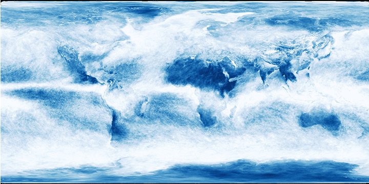 |
| Monthly averaged cloud covered across one year (2014) NASA |
Earth’s climate, just like its tectonics, is driven by heat transport between the warm surface below and the cold of outer space above. Really it’s beginning to seem like everything interesting that happens here (perhaps including life itself) is just an elaborate heat rejection mechanism for the planet.
But in this case the source of the heat is not the Earth’s interior,
but the sun: Sunlight passes through the atmosphere, mostly without interacting
with it, and then is absorbed by the surface; so while exposed to sunlight the
Earth’s surface is usually warmer than the air above it. The air itself is
warmer than outer space, so there’s a gradient driving heat transport upwards
from the surface. But because not all areas of earth are equally warmed by
sunlight, heat transport occurs not just between the surface and space but
between different areas of the surface as well.
To understand what effect this has, let’s consider a few
idealized scenarios. First, imagine that the Earth is a perfect sphere with a
smooth, homogenous surface, no obliquity, and no rotation—and yet still somehow
receives equal sunlight all along its equator (in essence, imagine a static
all-ocean planet that is surrounded by some kind of bright ring that replicates
sunlight).
In this scenario, high insolation
(power per area of incoming sunlight) at the equator causes it to be warmer
than anywhere else, and it heats the air directly above it; this warm air
expands and rises, until it reaches an altitude where the atmospheric pressure
is low enough that it is no longer buoyant—around 10 to 15 kilometers for Earth.
There’s still more warm air pushing up from below, so the air moves laterally
away from the equator and towards the poles. As it travels poleward the air
radiates heat into space, and by the time it reaches the pole it’s cooled down
enough to sink back to the surface.
Now we’ve got a lot of air moving away from the
equator—creating a low-pressure zone
at low altitude—and a lot of air converging at the poles—creating high-pressure zones. The cold air moves
down the pressure gradient back towards the equator, and absorbs heat from the
surface as it does such that it’s ready to rise again at the equator.
So the result is one large convection cell in each hemisphere, with warm high-altitude winds
carrying heat away from the equator and cool low-altitude winds coming back
from the poles. A neat, simple closed loop.
 |
| Lyndon State College Atmospheric Sciences |
Now let’s modify this scenario and rotate the planet at the
same speed as Earth, once every 24 (ish) hours; and in the same direction, to
the east.
Activity at the equator still looks much the same: warm air
rises from the surface and then is pushed polewards. But as warm air moves away
from the equator, it is still moving east at the same velocity of the equator
(around 1,700 km/h) while the velocity of the ground below it is decreasing.
From the ground’s perspective, this makes the air current appear to curve
towards the east as it moves poleward, what we call the Coriolis effect. The effect is strong enough that by the time the
warm air reaches 30° latitude,
it is moving almost due east.
Unable to move any further poleward, the air radiates some
of its heat, sinks, and then flows back to the equator. By now it has lost some
of its eastward velocity and matches that of the surface, so it starts to lag
behind the increasing velocity of the surface as it moves equatorward, and thus
it curves towards the west. So: on an eastward-rotating planet the Coriolis
effect causes:
- Poleward air currents to curve east, and
- Equatorward air currents to curve west.
 |
| Apparent deflection of poleward (red) and equatorward (green) winds due to varying surface velocity (shown on right). Paul Webb |
For westward-rotating planets it would be the reverse,
though I tend to think we should just define east as the direction a planet
rotates regardless of whether it’s prograde or retrograde relative to its
orbit.
Meanwhile, this leaves a lot of extra heat and a high
pressure zone at 30°, and
still-cold poles beyond. The warm air there cannot rise against the flow of the
sinking air flow from the equator, so instead it moves poleward at low altitude.
Once again the Coriolis effect causes it to curve east, such that it can only
make it to 60° latitude. By
this point it is sufficiently warmer than the surrounding air that it can rise
into the upper atmosphere, but as it does so it loses some of its heat to the
cooler surrounding air. The now-cooled air flows back equatorward to 30°, and sinks to complete the loop.
And then finally,
the warmed air at 60° flows at high altitude to the poles, then sinks and flows
back to 60° at low altitude.

So altogether,
there are now 3 convection cells in each hemisphere. From equator to pole, we
call these the Hadley cell, the Ferrel cell (a.k.a. mid-latitude cell),
and the polar cell. Heat still moves
from equator to pole, but it does it by jumping across convection cells; first
at high altitude to 30°, then low altitude to 60°, then high altitude again to
the pole. And in each cell, cool air flows equatorward at the opposite altitude
to close the loops of air flow.
But when we talk about climate, what we’re usually concerned
with is the conditions on the surface, so what we really care about are those low-altitude
winds—the prevailing winds—and the
pressure zones associated with them.
 |
| Pressure zones and prevailing winds caused by atmospheric circulation. Stevenson 2019 |
So between 30°
and the equator, the Hadley cell creates the easterly trade winds
(winds are named for the direction they blow from, not the direction
they blow towards, a convention I
always found confusing). They blow more directly west closer to the equator,
but still always tilted towards it. The Ferrel cell creates westerlies (tilted towards the poles)
at mid latitudes, and the polar cell creates (equator-tilted) easterlies at
high latitudes.
One thing to remember is that as these winds travel, they
carry moisture along with them—so in general high-pressure zones where winds
originate are dry and low-pressure zones where winds converge are wet. The
wettest area of the planet is the Intertropical
convergence zone (ITCZ) at the
equator, with fairly wet polar fronts at
60° as well. The driest areas
are the poles and the horse latitudes
at 30° .
 |
| Burschik, Wikimedia |
Now let’s modify
the scenario again, and add continents: Earth’s will do just fine for the
moment.
Different areas of
land and sea have different albedos,
meaning that they reflect or absorb different amounts of sunlight—higher albedo
means more light reflected and less heating for a given level of insolation. To
review, here are typical albedos for different surfaces on Earth:
Surface
|
Open Ocean
|
Dense Forest
|
Grassland/ Shrub
|
Desert
|
Ice/Snow
|
Albedo
|
0.06
|
0.08-0.15
|
0.1-0.25
|
0.3-0.4
|
0.5-0.8
|
This is only true for modern Earth, of course; different
stars, different minerals, and different lifeforms can all affect these values.
But it’s a good baseline to work from.
Clouds also have a high albedo, similar to ice, and wetter
areas will have more clouds, raising their albedo. On earth today this only has
a small effect on local climates, but on a global scale it raises the total
albedo enough to significantly cool the planet.
| Earth average surface albedo without (above) and with (below) clouds. Giorgiogp2, Wikimedia |
The effect of all this is that with continents present,
surface temperature is no longer solely determined by latitude; two areas at
the same latitude can receive different amounts of heating due to different
albedos. You might expect that the oceans, with the lowest albedo, would have
the highest temperatures then, but they have their own internal convection as
well (and also tend to have high cloud cover), so often the warmest areas are
on land.
All of this alters the exact geometry of the atmospheric convection
cells. The ITCZ, for example, no longer lies exactly along the equator but
swoops north and south through the hottest regions of the globe, and the polar
fronts are similarly affected.
And regarding local climates, the fact that the prevailing
winds do not flow directly north and south has important impacts on water supply:
Land areas downwind of oceans will be generally wetter, even at the horse
latitudes, while the opposite is true of areas upwind of oceans. Topography
also has an impact: higher terrain is generally cooler, and high mountains can
block the transport of moisture through the process of orographic lift (a subject for the next post).
Finally, we can introduce obliquity to our model; Earth’s axial tilt of 23.5°, which causes the seasons—where
maximum insolation shifts north and south, and so temperature and the atmospheric
convection cells do as well.
Water has a high specific heat, meaning it takes a
relatively large amount of heat to increase the temperature of a given mass of
water, and this combined with global ocean circulation gives the oceans a high thermal inertia—they resist temperature
changes better than land at the same latitude (wet land areas also have a
higher thermal inertia than dry areas, to a lesser extent). This means that
within each hemisphere, the land will heat up faster than the oceans in summer
and cool down faster in winter. Thus, the temperature contrasts between
different land and ocean areas become even more pronounced, and the ITCZ sweeps
large distances north and south with the seasons.
 |
| Mats Halldin, Wikimedia |
Where the ITCZ moves farthest, it causes monsoon patterns where regions of land
are wet in one season and dry in another. This can create rainforests in the
horse latitudes and deserts at the equator. The polar fronts move across the
seasons as well, which affects the severity of winters in temperate areas.
Forcings and Climate States
 |
| Concept of the surface of TRAPPIST-1f. NASA/JPL-Caltech/T. Pyle (IPAC) |
We’ll discuss all these fine controls of local climate—ocean currents, topography, monsoons—in more detail in the next post. What I want you to bear in mind for now is this overall model for how the interactions of insolation, atmospheric convection, the Coriolis effect, surface albedo, and obliquity create the climate we have. This is the baseline we will be working off—that of our modern Earth.
What I want to do for the rest of the post is look at global
climate forcings: conditions that
can cause dramatic increases or decreases in average temperature or
precipitation, or dramatic shifts in the distribution of temperature and
climate zones across the planet. A stable climate is an equilibrium between the
many different forcings acting on a planet. When a forcing becomes stronger or
weaker (say, for example, a sudden increase in CO2 supply to the
atmosphere) then the climate begins to change until it achieves a new
equilibrium.
For example, one strong forcing on climate is planetary
albedo; higher albedo lowers the average temperature. Ice has a much higher
albedo (0.5-0.9) than liquid ocean water (0.06) and most other types of land
cover (0.08-0.4) so increasing ice coverage lowers the planet’s average
temperature. Of course, lower temperature increases ice coverage, which lowers
temperature, and so on. The same can happen in reverse; high temperature causes
ice to melt, which raises temperature, etc.
This positive feedback effect, called ice-albedo feedback, can amplify small initial temperature shifts
into a major climate transition. I’ve mentioned before
how it can render seemingly hospitable planets uninhabitable, but it also
operates on finer scales as well. In these cases it is eventually stopped by
stronger negative feedbacks (typically the carbon-silicate
cycle; also discussed in the linked post above) or it reaches limits of
effectivity: If the ice caps melt completely, or if they grow to the point of
extending into deserts that already had a high albedo, then further temperature
changes cause a smaller change in albedo.
There are many such feedbacks between climate forcings.
Because of this, the Earth rarely transitions gradually between different
climates. The trend in the past has been for the planet to leap between
discrete climate states, which it inhabits for long periods before a
sudden change in conditions causes it to leap again. In some cases the same set
of external forcings—astronomical conditions, initial planet size and
atmospheric content—can allow for multiple stable climate states, with the
particular history of the planet determining which one is inhabited at the
present.

Throughout its past Earth has fluctuated between three main climate states (exact terminology varies):
Hothouse states (A.K.A. greenhouse states), with warm seas, no polar icecaps, and few or no
glaciers on land. This has been the default for the last half-billion years,
perhaps for Earth’s entire history. The poles likely still have seasonal snow,
but in the warmest periods they may come to resemble tropical rainforests in
summer. High sea levels also mean broad shallow seas around the continents,
ideal for marine life. But as a tradeoff, arid regions are probably more
hostile, and life has to adapt to high humidity in the tropics (some sources
distinguish between regular greenhouse and especially hot super-greenhouse or
hothouse states, but I won’t bother here).
Icehouse states (A.K.A. ice ages), with cool seas, ice caps, and extensive glaciers. We
currently inhabit an icehouse state which began 2.5 million years ago. This
period has itself been divided into two climate substates: Interglacials like today, with fairly small ice caps, and glacials, with large glaciers extending
into midlatitudes and sea levels falling by tens to hundreds of meters.
Throughout the icehouse period Earth has fluctuated between glacials and
interglacials on a roughly 100,000 year cycle, with glacials usually lasting
longer, driven in part by variations in Earth’s orbital and rotational motion.
Previous icehouses have probably had similar cycles.
Snowball states, with total or near-total coverage of
the surface in glaciers and ice sheets. Exactly how total remains a matter of
debate; It may be possible for a thin strip of unfrozen ocean to remain near
the equator,
what some call a slushball state. In
either case, the poles are essentially uninhabitable except by deep-sea life,
and these states are generally a challenge to the survival of complex life. The
last snowball ended 650 million years ago; so in Earth’s history they’re fairly
rare events, but this may not be true of all planets.
A fourth state, the moist
greenhouse state, will occur
in the future when Earth passes the inner boundary of the habitable zone. In
this state large amounts of water evaporate into the upper atmosphere, warming
the planet above habitable temperatures and gradually escaping into space. When
the oceans are lost completely, CO2 builds up in the atmosphere and
warms the planet further, likely sterilizing it completely. Fortunately, such
states appear to be very difficult to attain for planets in the habitable zone.
We can regard hothouses and snowballs as end states of the
range of habitable climates, with icehouses as an intermediate state. Earth
appears to be biased towards the hot end of the range, but this may not be true
for all habitable planets. Stronger positive feedbacks like ice-albedo feedback
make it harder for planets to occupy an intermediate state; a planet with
stronger feedback due to, for example, higher obliquity, will cause a planet to
jump straight between hothouse and snowball states.
Knowing that the strength of one climate forcing can affect
another, accounting for all of them is a very difficult task. Trying to isolate
the effect of one forcing is perhaps just as difficult. Nevertheless, let’s go
through some of the most impactful forcings affecting Earth and similar
exoplanets, and try to get a sense of what effect they each have.
Astronomical Forcings
These are forcings originating from the star system around a
planet, and the planets motion through it. These are the strongest forcings,
and I’ve discussed many in the past,
but only to the point of what does and does not allow for habitability. Now I
want to dig in a little deeper to the effects of subtle variations in these
forcings within the constraints of habitability.
Three of the forcings we’ll discuss are all closely linked
together: Star type, insolation, and orbital period. For a given star type, insolation
and orbital period are both determined by semimajor axis, so one cannot be
changed without affecting the other; and for different star types, keeping the
same insolation requires altering the period, and vice-versa. But we’ll try to
consider them independently as much as we can, and focus on the strongest
effect of each individual forcing.
Star Type
To review, we went over the various types of potentially
habitable stars back in Part II,
and determined that within the main sequence, more massive stars are
brighter, bluer, and evolve faster, and less massive stars are dimmer, redder,
and longer-lived. Though I’m mainly concerned with main-sequence stars, the
effect on climate mostly comes down to the spectrum of light produced by the
star; so e.g. the climate of a planet orbiting a red giant should be similar to
that orbiting a red dwarf and receiving equal insolation.
The most important effect of a star’s spectrum, the
particular wavelengths of light it produces, is that a planet’s surfaces will
have different albedos under different spectra. In particular, ice absorbs more
infrared light than visible light. Were Earth transported into orbit of
a red dwarf star with the same insolation and no other changes, it would absorb
so much more light and be so much warmer that it may no longer be habitable—for
stars with effective temperatures less than about 5,000 K, such a scenario
would put Earth inside the inner boundary of the classical habitable zone,
which should push it into a runaway greenhouse state (though some models suggest
that alterations in cloud behavior may still result in habitable, if
sweltering, conditions).
In general, Earthlike planets should have planetary albedos
0.1-0.2 lower around M-type stars than G-type stars.
To keep the same climate, an unaltered Earth would have to receive 12% less
insolation compared to what it receives now when orbiting a typical M-type
star, and 8% more insolation when orbiting an F-type star.
But for planets that are in the HZ of red dwarfs, ice-albedo
feedback would be weaker, and so climate transitions can be expected to be
smaller and more gradual. Pole-equator temperature and humidity differences
will be smaller as well, and ice caps smaller for a given average temperature—though
weaker ice-albedo feedback increases the likelihood of partial ice cover in
general.
 |
| Shields et al. 2019 |
But it’s not all good news: Because it absorbs less light,
water would also be less prone to evaporation and so such a planet would have
around 10% less global precipitation at a similar average temperature to Earth.
Also, once insolation drops below 65% relative to Earth, hydrohalite ice may begin to form that reflects more strongly in
infrared and so causes stronger ice-albedo feedback again (though, as we’ll see
in a moment, it’s generally weaker at lower insolation anyway).
Albedo also affects the impact of photochemical hazes, like the tholin haze of Titan or possible
hydrocarbon haze of early Earth.
F-type stars produce high UV radiation that will act to decompose the haze,
while M-type stars produce mostly infrared light that will pass through the
haze; so it is only around G- and K-type stars that these hazes can
significantly cool a planet.
Finally, the other big factor to consider in relation to star
types—in particular when reading the next section on insolation—is that of star
lifetime and evolution: If a planet is orbiting an F-type star that evolves so
quickly that the planet can only remain in the habitable zone for 5 billion
years or less, then by the time complex life has developed on this planet
(presuming it takes about as long as on Earth and the planet had to remain in
the HZ the entire time) it must be close to the inner edge of the HZ. The same
would apply for red giants as well, which evolve on similar timescales.
However, such a planet could have developed with an early
methane or hydrogen greenhouse, as discussed before,
so this is not necessarily always the case.
Insolation
Light from the sun is, of course, the largest forcing acting
on Earth’s climate, and it’s fairly obvious that if we increased insolation and
changed nothing else, Earth would warm up.
But we know that,
within the limits of the habitable zone, the carbon-silicate cycle will
compensate for increases in warming by insolation by lowering CO2
levels and so reducing greenhouse warming. But this doesn’t mean there’s no
effect; At lower CO2 levels the chemical processes that sequester CO2
are less efficient, so a higher temperature is required to make sequestration
match outgassing.
Thus, an Earth with the carbon-silicate cycle at equilibrium
(and enough CO2 outgassing to avoid snowballing or limit-cycling,
which may or may not be at Earth-equivalent levels depending on whom you ask)
at the inner edge of the conservative habitable zone (with about 112% Earth’s
current insolation) would be around 10 °C
hotter, and one at the outer edge (36% current insolation) around 15 °C cooler, close to freezing.
Though the habitable insolation range is different for other stars, the range
of resulting temperatures should be similar.
 |
| Predicted average temperature for given insolation with CO2 outgassing equivalent to Earth (light grey) or 5 times greater (black); this model suggests the former is too low for habitability in the outer HZ. Kadoya and Tajika 2019 |
However, exactly where the inner boundary is and what sort
of climates should appear there is still a matter of debate. Conventional
habitable zone models predict that more than 10% increased insolation would
push the planet into an uninhabitable moist greenhouse, but more detailed models predict that shifts in atmospheric circulation and cloud formation could
keep the climate stable at up to 21% increased insolation.
But by this point average temperatures would exceed 70 °C, and CO2 levels would fall so low that no modern plant life could survive.
The very humid atmosphere would distribute heat very evenly across the Earth,
so not even the poles would remain cool. Any remaining life would either have
to dramatically change its biochemistry or retreat to the deep oceans—though
even those would be lost to space in under a billion years.
Going the other way, as we move further out in the habitable
zone warming from initial absorption of sunlight decreases and greenhouse
warming increases, so surface albedo and relative insolation become less
important; ice-albedo feedback weakens and equator-pole temperature difference
decreases. Once the atmosphere has over 3 bars of CO2, the feedback
is essentially gone.

In spite of this, snowballing or limit-cycling become more
likely in the outer habitable zone, because the minimum threshold of volcanic
CO2 outgassing required for the carbon-silicate cycle to operate
increases. Below 62% of Earth’s current insolation, recovery from snowball also becomes more difficult due to formation of CO2 ice at the poles.
So to keep hospitable conditions, these planets would have to either avoid
snowball states entirely or compensate with very high volcanic outgassing
rates.
Orbital Period (Year Length)
Year length is intimately tied to star type and insolation,
both stronger forcings, so there’s been little analysis of the effects of year
length alone. But one obvious effect is that longer years means longer seasons,
and so more time for increased insolation near the poles to overcome thermal
inertia. On Earth the equator stays significantly warmer than the poles
throughout the year, but with years 4 times as long the poles may become warmer in summer and the equator undergoes solstice winters and equinox summers just
as on a high-obliquity planet.
 |
| Each chart shows insolation (lines) and temperature (shading) at different latitudes (vertical axis) throughout the year (horizontal axis), and different charts represent different combinations of year length (ω, vertical axis) and obliquity (γ, horizontal axis). Guendelman and Kaspi 2019 |
But really most habitable worlds are likely to have shorter
years, and so milder seasons. A shorter year also introduces more “lag time” (relative
to the year length) between the solstices and polar seasons; at years 1/4 as
long, midsummer comes closer to the fall equinox than the “summer” solstice.
Greater pole-equator temperature differences should also
lead to stronger and somewhat wider Hadley cells, with the ITCZ moving farther
poleward with the seasons.
Rotational Period (Day Length)
These are not actually exactly the same; the sidereal day,
the time it takes the planet to rotate once around its axis, is shorter than
the synodic day, the time it takes the star to complete one apparent circuit
through the sky (for a prograde-rotating planet). Where the day is much shorter
than the year, the difference is small enough to be negligible. Where it is
not, tidal forces are likely to lock the planet into a spin-orbit resonance,
including 1:1 tidal-locking where the synodic day is effectively infinite, but
the climates of such planets are so dissimilar from fast-rotating planets that
we’ll leave discussion of them to another day.
Rotation causes the Coriolis effect, and faster rotation
causes a stronger Coriolis effect. This means equatorward-flowing air will
curve eastward faster, and so the Hadley cell will extend to lower latitude.
For slower rotation, the reverse will happen.
However, the Coriolis effect is not the only factor
determining the width of the Hadley and other circulation cells; friction
between ground and atmosphere and formation of eddies near the equator have an impact as well. So the Hadley cell widens with longer days, but not as neatly
as you might expect from the Coriolis effect alone.
 |
| Latitude of the top of the Hadley cell (i.e., location of the horse latitudes) for different rotation rates compared to Earth (e.g., days twice as long would be a rotation rate of 0.5 Ω). Kaspi and Showman 2015 |
As the Hadley cell widens, its associated pressure zones and
prevailing winds must shift as well: The dry horse latitudes will shift north,
and the easterly trade winds prevail over a larger area of the planet.
The other cells must shift poleward as well, though because
they’re weaker their patterns can be a bit harder to predict. When an Earthlike
planet has day lengths equal to 4 Earth days, the polar cells disappear; air
rises at the poles and sinks at the poleward-shifted horse latitudes, in spite
of a thermal gradient pushing air the other way.
At 16 days the Ferrel cells are also reduced to almost
nothing, and a single massive Hadley cell dominates each hemisphere. But at the
same time, complex momentum transfer in the upper atmosphere causes superrotation, circulation of air
faster than the planet rotates, and so some westerly winds appear at the
equator. Superrotation is also responsible for the Y-shaped clouds we can
sometimes see on Venus, so we might expect similar cloud formations on these
worlds (On Venus these clouds are only visible in UV, but this may be different for a habitable world with less atmospheric haze).
 |
| Venus's clouds in UV; the "Y" points antispinwards, as the equatorial clouds circle the planet slower than the polar clouds and so lag behind them. NASA |
Conversely, doubling the rotation rate (days half as long as
Earth) creates two new circulation cells in each hemisphere, continuing the
pattern of alternating easterlies, high-pressure zone, westerlies, low-pressure
zone. Further increases in rotation rate create even more convection cells. At
less than 1/4 days it becomes difficult to count the exact number of cells due
to eddies crossing between them and the relative weakness of each individual
cell, and indeed the number may not be fully symmetric across the hemispheres
or consistent across seasons; but air is consistently rising at the equator and
sinking at the poles, implying an odd number in each hemisphere at all times.
Based on this paper,
I’ve tried to measure out the approximate latitudes for the predicted convection cell
boundaries in each hemisphere:
Day Length (Earth Days)
|
Convection Cell Boundaries (° Latitude)
|
||||||||
16
|
3
|
70
|
|||||||
8
|
0
|
65
|
|||||||
4
|
0
|
55
|
|||||||
2
|
0
|
40
|
70
|
||||||
1
|
0
|
30
|
60
|
||||||
1/2
|
0
|
25
|
40
|
55
|
70
|
||||
1/4
|
0
|
18
|
21
|
26
|
33
|
41
|
49
|
56
|
64
|
Pressure
|
Low
|
High
|
Low
|
High
|
Low
|
High
|
Low
|
High
|
Low
|
Wider Hadley cells—helped along by stronger ocean currents—means more efficient heat transfer, and so a smaller equator-pole temperature difference for longer days. It also tends to lead to more regular and predictable wind patterns, and so fewer large cyclones.
 |
| Kaspi and Showman 2015 |
Total average temperature increases with day length up to 4
days by about 5 °C due to
decreasing cloud formation at high latitude, then decreases thereafter due to
increasing cloud formation during the long days; as much as 10 °C lower than current average
temperature at 16 days, and 20 °C
lower at 256 days
(though in the latter case that’s an average between a long, cold night and
equally long, sweltering day).
 |
| Black: Clouds and 50-meter-deep global oceans (Earthlike) Blue: Clouds and 1-meter-deep oceans (desert planet) Red: No clouds and 50-meter-deep oceans (probably an unrealistic scenario). Yang et al. 2014 |
 |
| Average surface temperatures (top) and portion of the surface with temperatures between 0 and 100 °C at different levels of insolation (bottom) for different day lengths in a zero-obliquity model (the maps above correspond to the data points below). Jansen et al. 2018 |
Indeed, the effect of rotation rate on precipitation depends stronger on the planet’s obliquity. At very low obliquity, widening of the Hadley cells increases precipitation at mid latitudes (~10-50°) but weakening and then disappearance of the polar cell reduces it at high latitudes; areas poleward of 60° will become mostly arid at 8 days or longer.
 |
| Average land precipitation at different latitudes (excluding those with no land on Earth) at different day lengths and levels of insolation, using zero obliquity and Earthlike topography. Jansen et al. 2018 |
But with Earthlike obliquity, the wider Hadley cells allow for the ITCZ to move farther with the seasons. Past 8 days, it reaches almost to the poles near the solstices, causing heavy rains there and leaving the equator relatively dry. In essence, these planets have one giant planet-spanning convection cell near the solstices.
 |
| Average precipitation (mm/day) at different latitudes across the year at different rotation rates, using Earthlike obliquity and no topography (global ocean). Faulk 2017 |
As a final note, longer days for melting and longer nights
for freezing lead to stronger ice-albedo feedback, especially past 10 Earth
days. But while the proclivity towards a hothouse climate with no permanent ice caps increases, the proclivity towards a snowball state doesn't, so this may not be a big issue for habitability.
Obliquity
A.K.A axial tilt, the angle between a planet’s equatorial plane and its orbital plane, which is also the highest angle that the sun will appear above the horizon at the poles and the highest latitude that will see the sun directly overhead at summer solstice (for obliquities up to 90°; planets with obliquities above 90° are essentially identical to planets with obliquities equal to (180° - obliquity) in terms of climate, unless the rotational period is a significant portion of the orbital period). Any latitudes greater than (90° - obliquity) will receive daylong sun for at least part of the summer, which can cause them to receive higher average insolation over the day than lower latitudes, even if peak insolation at noon is lower.
I talked about obliquity
and its relationship to seasons back in Part IV, but just to review:
- Obliquity causes Earth’s seasons because the insolation of each hemisphere increases and decreases as it is pointed towards or away from the sun.
- Higher obliquity decreases the difference in average temperature between equator and pole (to ~50°), but increases seasonal temperature variability.
- Past 18° obliquity, the poles receive more insolation than the equator at the summer solstice.
- Past 45°, the sun is higher in the sky at the poles than the equator at summer solstice.
- Past 54°, the poles receive more average insolation throughout the year than the equator (they still has lower insolation in the winter and during equinoxes, but this is offset by the constant summer sun).
- Any nonzero obliquity will cause the poles to experience summer and winter at opposite solstices, while high obliquities cause the equator to experience 2 equinox summers and 2 solstice winters every year.
Increasing
obliquity somewhat increases average global temperature due to shifts in cloud
cover—by about 9 °C from 30° to 90° in otherwise Earthlike conditions. In the other direction, an Earth with no
obliquity would be about 4° C colder than today, with permanent polar icecaps
extending to ~ 50° latitude. But where a low-obliquity world has
comfortable temperatures, they should be near-permanent, while at high
obliquity the whole planet will experience large seasonal temperature swings.
 |
| Average temperature across the year at different latitudes for different obliquities (using an idealized global ocean planet). Nowajewski et al. 2018 |
Past ~50°, our
assumption in the model scenarios at the start heat flows from equator to poles
is no longer valid. Exactly what happens to atmospheric circulation depends on insolation and rotation rate:
At high insolation
or low rotation rate (in both cases the transition is near Earth-equivalent
values), the major circulation cells are still present, but they switch
direction; hot air rises at the pole and cool air sinks at the equator, and so
prevailing winds will switch direction as well. These flipped wind patterns
will cause moisture to converge at the poles in summer, which could make for intense
seasonal storms. However, summer temperatures over the
continents could become so high that rain cannot occur even at high humidity,
so a typical summer includes an extended drought followed by torrential
downpours in fall. Elsewhere, precipitation is distributed
fairly evenly over the summer hemisphere (the boundaries of the convection
cells aren’t as impactful as at low obliquity, and move far over the year), but
the equator remains dry.
 |
| Average precipitation in different months with 85° obliquity. Williams and Pollard 2003 |
At low insolation
or high rotation rate, eddy patterns near the equator and friction between the
ground and atmosphere help to keep the circulation cells going in the same
direction as they do at low obliquity, but with far weaker Hadley and polar
cells, wider Ferrel cells, with the ITCZ moving much farther over
the year; some heat is still transported from pole to equator, but we can
assume these worlds have higher equator-pole temperature differences and are
more prone to glaciation.
Of course, varying
rotation rate affects the number and strength of circulation cells as well, but
we won’t work through all the possible variants here; though one intriguing
possibility at particularly low rotation rates is that there may be a single
convection cell from one pole to the other that switches direction across
seasons.
In either case, winds
are fairly weak in winter and temperatures fairly similar across most of the
winter hemisphere because a large part of it receives the same amount of
insolation; zero. Nevertheless, oceans at any latitude can
remain ice-free throughout the year; average sea level temperature at the poles
for an Earthlike planet with 90° obliquity and good ocean circulation varies
between 12 and 42 °C over the year. But continents are more variable, and deep
interiors at high latitudes can reach -30 and 100 °C under similar conditions. Such extreme temperatures—along with the
aforementioned seasonal rain patterns—could be a major challenge for any life
on such a planet.
 |
| Average surface temperature in different months with 85° obliquity. Williams and Pollard 2003 |
Intriguingly, it is possible for planets with over 54° obliquity and fairly weak equator-pole ocean
circulation to develop an equatorial ice belt without permanent ice caps at the
poles; it just requires that the entire planet
freeze over first, and then the poles thaw. An equatorial ice belt with
seasonal polar ice cover is also possible above 30°.
Meanwhile, Earth’s
current condition—permanent polar ice caps with an ice-free equator—is only possible up to 35°, and only from an initially fully thawed state; for low-obliquity planets, recovery from
a snowball necessarily results in total loss of the ice caps.
 |
| Chart of conditions under which it is possible to attain certain climate states starting with global ice cover (left) or no ice (right); cryoplanet (global ice), near cryoplanet (equatorial ice belt and seasonal polar ice caps), uncapped cryoplanet (ice belt and ice-free poles), capped aquaplanet (ice caps and ice-free equator, like Earth), near aquaplanet (seasonal ice caps), and aquaplanet (no ice). Carbon-silicate cycle isn't accounted for, so think of "relative stellar irradiance" not as literal insolation but more an abstract representation of relative warming or cooling, with the widths of climate states representing how stable they are at different obliquities. |
Note, by the way,
that it appears possible for a planet at 30-35° to have polar ice caps and an
equatorial ice belt at different points in its history, though this is the
obliquity range where ice-albedo feedback is strongest and so partial ice cover
is least likely at any given point in time.
But of course, that
can happen to any planet if the obliquity varies over time. Earth’s obliquity
oscillates between 22.1° and 24.5° and back over a 41,000 year period, one of
the so-called Milankovitch cycles.
Small though this variation is, the shift in polar insolation it causes seems
to be a major factor in the glacial-interglacial cycle. Any planet in a system
with other planets influencing it is likely to undergo such cycling (you can
use orbe to get a sense of it for a given system if
you like). In certain systems—multiple star systems especially—these cycles might be much shorter, as
little as 1,000 years, causing constant rapid shifts in climate.
The amplitude of these variations can vary as well: From its
current value of 25°, Mars’s
obliquity has likely varied from to over 60° and under 10° over its
history.
One last thing to remember: obliquity is not a free value.
Initial obliquity could be more-or-less anything thanks to large impacts late
in planet formation, but tidal forces from a star or moon will tend to reduce
it over time. The forces from the star are stronger in the habitable zone for
lower-mass stars, to the point that it’s near impossible for a habitable planet
to retain any high obliquity for billions of years around a red dwarf.
However, the gravitational influence of other planets could
help maintain some obliquity in these cases, and encounters with other stars
could alter the inclinations of these planets—in effect, changing their
obliquity.
 |
| Armstrong et al. 2014 |
Eccentricity
Variation of the distance between star and planet due to an elliptical orbit. This is an interesting case of a forcing that is almost
absent on Earth but may be significant for other planets. For a given semimajor
axis, higher eccentricity slightly increases average insolation, and so leads
to increased average temperatures—around 10-20 °C from 0 to 0.5 eccentricity. But with increasing eccentricity
comes an increasingly short and intense periapsis summer and a long apoapsis
winter. These higher temperatures are accompanied by higher average
precipitation, with an annual cycle of wetter low latitudes near periapsis and
wetter high latitudes near apoapsis.
 |
| Temperature across the year with varying eccentricity, Earthlike obliquity, and a solstice at periastron. Dressing et al. 2010 |
In general higher eccentricity seems to cause lower
equator-pole temperature contrasts and weaker ice-albedo feedback.
But exactly how it affects temperature and circulation patterns depends on how it
interacts with obliquity. If periapsis lines up with a solstice, it will
strengthen seasons in one hemisphere and weaken them in the other; if it lines
up with an equinox, hemispheric seasons will be generally milder but with
spring/fall transitions varying across hemisphere and low latitudes will
experience an annual seasonal cycle.
At low eccentricity, whichever hemisphere has its summer solstice
closer to periapsis should be warmer on average and have smaller ice cover. But
at very high eccentricity and fairly low insolation, the winters in that
hemisphere are so long that an ice cap forms that cannot be fully thawed in the
intense but brief summer, and so this becomes the colder hemisphere.
Earth’s eccentricity undergoes its own Milankovitch cycles,
somewhat more erratic than the obliquity cycles but with a roughly 100,000-year
period. The orientation of Earth’s rotational axis and the position of
periapsis in Earth’s orbit oscillate as well, combining to create a roughly
23,000-year period between times when periapsis coincides with northern summer
solstice. At such times the ITCZ moves further north in summer, bringing more
moisture into what are currently dry deserts and causing periodic “greenings”
of the Sahara.
The southern hemisphere likely has broader arid zones at the same time,
with the situation reversed when periapsis coincides with northern winter
solstice.
Altogether this is a secondary control on the
glacial-interglacial cycle, but in a world with higher eccentricity it could be
the primary control.
Planet size
Though not an element of a planet’s motion, I’m including
this as an “external” astronomical factor, given that it’s set at the end of
formation and cannot be changed afterwards without effectively sterilizing the
planet. We’ll assume all our habitable planets have roughly the same
composition as Earth, and so mass, radius, and surface gravity are all closely
linked.
Unsurprisingly, increasing radius causes a greater
equator-pole temperature difference, because the heat has farther to travel—though
the actual gradient of temperature change over distance decreases, thanks in
part to how greater gravity affects air flow.
A planet with higher density than Earth but the same radius would have a lower
equator-pole temperature difference instead.
 |
| Equator-pole temperature difference (Blue, left bar) and gradient over distance (Red, right bar, equivalent to °C / 1,000 km) for planets with constant, Earthlike density of 5.52 g/cm3. Kaspi and Showman 2015 |
Greater gravity also reduces the content of water vapor in
the air, reducing the greenhouse effect and therefore lowering surface
temperature by a few °C.
This will probably reduce overall precipitation as well.
Geological Forcings
Those related to tectonic activity, continental drift, or
other geological processes on the surface. These can all change over a planet’s
lifetime regardless of the wider astronomical context.
Volcanic Outgassing
This is perhaps the most direct way to alter average global
temperatures. Other forcings will be restrained by the carbon-silicate cycle,
at least to some extent, but altering the rate at which CO2 and
other greenhouse gasses are emitted by volcanoes directly alters the
equilibrium point of the carbon-silicate cycle. So I’ll take this opportunity
to talk not only about how this rate can change and what effects that will
have, but also about how shifting global temperatures in general (which can
still be caused by other factors) affects other climate factors.
I’ve described the carbon-silicate cycle before,
but in short it’s the cycling of carbon by outgassing from volcanoes as CO2,
weathering of surface minerals with CO2 and water to form dissolved
bicarbonate, deposition as carbonate minerals, subduction into the mantle, and
then decomposition back into CO2 dissolved in magma that rises to
the surface again. Because increased CO2 increases temperature and
increased temperature increases weathering that draws CO2 out of the
atmosphere, a stabilizing negative feedback results: when other factors alter
the global temperature, CO2 levels will tend to increase or decrease
until the rate of weathering once again matches the rate of volcanic
outgassing. But if the rate of outgassing changes, then the temperature at
which this equilibrium is reached changes.
Thankfully, it shouldn’t change by much; small changes in
temperature cause large changes in the weathering rate. So long as rates of
volcanism don’t rise to something like Io or fall to something like Mars, we
should stay comfortably within habitable temperatures. But the subtle effects
are worth some consideration.
For one thing, plate tectonics is, while smoother than most
of the alternatives, not a perfectly smooth ride. Events like the closure or
opening of oceans or other shifts in the global geometry of tectonic plates will
cause (relatively) rapid shifts in plate motion, accompanied by increased
volcanism, and so increased temperatures by a few °C.
But once this episode of increased tectonic activity ends, it’s likely to have
left behind large areas of exposed, young rock that can continue weathering for
tens of millions of years. Just as increased volcanic outgassing raises the
temperature at which the carbon-silicate cycle balances, increased potential
for weathering lowers it.
Such a pattern pretty well explains climate shifts over the
last 66 million years, the Cenozoic Era.
Early in the Cenozoic, intense subduction zone volcanism across the entire
western coast of the Americas and around the edges of the Tethys sea caused
high temperatures, peaking in the Eocene around 50 million years ago at around
30 °C.
Since then, most subduction in North America has ceased (for now) and the
Tethys has closed, ending much of the volcanism and leaving large mountain
ranges (the Rockies, the Himalayas, etc.) to weather down (there have been some
new island arcs forming with active volcanism, but these seem to have a smaller
impact on climate). Thus, temperatures have dropped, to 15 °C today and as low as 9 °C in the depths of a glacial episode.
 |
| Average temperatures over the last 66 million years. Hansen et al. 2013 |
And of course, under different tectonic regimes
the rates of volcanism could be much more variable, leading to larger and more
rapid shifts in climate. Though it causes its upsets, faster plate motion tends to decrease climate variability overall.
An episodic or sluggish-lid mode with long periods of slow motion and less
vigorous volcanism may allow for wild swings in climate beyond what we’ve seen
in the last ~800 million years of modern plate tectonics.
On any planet, the rates of volcanic activity should
generally decline over time. What effect this has on climate depends on how
this decreasing forcing from volcanic outgassing compares with the increasing
forcing from the brightening star. On Earth, the two trends appear to be
balanced, but it’s hard to say with poor long-term temperature records. Presuming
this is the case, and presuming that most habitable worlds will orbit smaller,
slower-evolving stars, the general tendency for Earthlike worlds may be to cool
as they age. The general increase in continental area—weatherable land—over
time may help as well (presuming that trend actually holds for older planets).
So what effects will increasing or decreasing the global
average temperature have on other climate factors? First off, increased
evaporation and other shifts in atmospheric circulation tend to make dry areas
drier and wet areas—particularly the tropics—wetter.
The distribution of these areas will change as well; the Hadley cell widens by
about 1° latitude for every 4 °C of increased average temperature,
pushing the horse latitudes poleward.
But as the ice caps melt, polar albedo decreases and so the
equator-pole temperature difference goes down as well. Mid Cretaceous hothouse
seas were around 5 °C hotter at
the tropics, but as much as 20 °C
hotter near the poles.
This causes the trend of a widening Hadley cell to reverse: from a peak width
of 35° latitude at 21 °C (perhaps cooler in a world with
lower insolation or redder starlight) it shrinks down to 20° latitude, pulling the horse
latitudes towards the equator and concentrating tropical rain into a thin
equatorial belt. This shrinking likely happens much more rapidly than the
initial widening of the Hadley cell.
 |
| Hasegawa et al. 2012 |
Going to the other extreme, a snowball planet would have
fairly low thermal inertia across its surface, and so the convection cells
would move far poleward with the seasons.
The equator would spend more time near the dry edges of the Hadley cells than
near the wet ITCZ—not that it would matter much to surface conditions, given
that the whole planet would be dry and there’d be little in the way of open
surface sediment on which vegetation could grow.
If, as some models predict, there could be a thin belt of
open ocean around the equator, then the low albedo of this area would keep it
far warmer than the icebound areas, and so the ITCZ should remain close to the
equator year-round even at fairly high obliquity. So the open area would have
some precipitation year-round, but it still may not be much overall. The
coldest climate with open water remaining—what researchers have termed a Jormungand
state (because the water belt resembles a world-encircling snake)—has ice
reaching to 10° latitude
(averaged across the seasons), global average temperatures below -10 °C, poles plunging below -80 °C, and Hadley cells only 20° latitude wide with tropical rains
less than half those today.
 |
| Average temperatures at different latitudes for hothouse (red), Jormungand/"slushball" (blue) and snowball (black) states, with Earthlike obliquity. Abbot et al. 2011 |
Land/Water Ratio
The total area of the planet’s surfaces with land, compared to the
amount with oceans, without necessarily accounting for the depths of the oceans
or ice cover. This ratio will be determined in part by the age and tectonic
history of the world, and in particular I’ve established before that a world
with more land than ocean is unlikely to have functioning plate tectonics. But
we’ll ignore the deeper implications of that here, and just consider the impact
of altering land area on its own.
Generally speaking, we tend to refer to worlds with a higher land/water
ratio as “dry”, and in a broad sense this is true, but it can be a bit
misleading regarding the critical factor of how much land area with frequent
precipitation—i.e., fertile ground—there is. A supercontinent will have
less fertile ground than multiple continents that have more total area but are
individually smaller. In the extreme cases, an ocean world with a small
continent and a desert world with a small sea could have similar areas of
fertile ground.
But regarding broad impacts on climate, there are a few clear points:
Land has a higher albedo than open water, so all else being equal a world with
more land will be cooler. Earth with all land removed (and no alteration in CO2)
would be a few °C warmer than today. There’s also a
lower contrast in albedo between ice or snow and land, as opposed to ice and
ocean, so ice-albedo feedback is weaker with more land area. A planet in the
outer habitable zone with low volcanic activity may avoid limit cycling for billions of years longer with 50% land area as opposed to 10% land area.
More area for weathering will cool the world as well, though weathering also
requires water so this may be less true at very high land areas. Except for
planets that have very high rates of CO2 outgassing, the difference
in weathering between 50% land area and 1% is unlikely to account for more than
a 10 °C difference—and even for high-CO2 planets, the effect is only
significant below ~10% land area.
 |
| Likely average temperature for different land areas and initial carbon contents. Foley 2015 |
As land area increases, ocean circulation will become more restricted and
eventually blocked, cooling the poles and warming the equator. Less water also
means less thermal inertia, so there will be major temperature swings with the
seasons. Overall, then, more land increases temperature contrasts.
In the most extreme cases, of dry planets near the inner edge of the
habitable zone (which can be much further in for such worlds), water must be
restricted to strips around the poles. Still, the seas here can extend pretty far equatorward—to 70° latitude or more—even while average temperature at the
equator surpasses 100 °C. Precipitation
will be concentrated towards the poles, but still even lower than these regions
receive on Earth.
Continental Drift
Even for a given amount of land, the position of that land
can have a profound effect on climate. Though continents are generally cooler
than oceans anywhere on the globe, when near the poles they have a better
chance of developing large glaciers, cooling themselves and the whole planet. The
drift of the continents towards the poles throughout the Cenozoic is another
possible factor in the Earth’s gradual cooling trend.
 |
| Average temperatures (°C) at different latitudes for different land distributions. Source |
The large interiors of supercontinents receive little
precipitation from the distant coasts, and are also far from the temperature-moderating
effects of the oceans. Central Pangea likely surpassed 50 °C in summer.
Winter is similarly cold, but that summer heat can help prevent glaciation even
when the supercontinent is over a pole—though supercontinents also tend to have
high internal mountains, which can help kickstart the glaciation process.
The position of continents also affects the pathways
available for ocean circulation. A broad east-west strip of continent at
mid-latitudes can block ocean transport of heat poleward, leaving the poles
several °C cooler than they
would be otherwise. But open ocean can have a cooling effect as well in the
right circumstances: A ring of uninterrupted water circles Earth at 60° south latitude, near the average
position of the southern polar front, resulting in a circumpolar current
circling the world that, to some extent, isolates Antarctica from warmer waters
near the equator. How much is still debated—it probably wasn’t necessary for
glaciation, but contributed to it.
Overall, shifts in ocean circulation seem to be a secondary factor in global
climate.
How the specific geometry of land and ocean can cause
warming or cooling at high latitudes is a subject we’ll dig into more in the
next post.
And, of course, the position and movement of continents is
linked to rates of volcanic activity and mountain formation, and through these
outgassing and drawdown of CO2.
Young mountains in the hot, wet tropics especially seem to increase
weathering and so decrease global temperatures.
Breakup of supercontinents may bring high rains into what was once dry interior
terrain, increasing weathering and cooling the climate—though perhaps only
briefly before plate speed and volcanic outgassing picks up.
Ocean Salinity
The salt content of water affects its freezing temperature
and density. Ocean salinity has been gradually declining over the last
half-billion years,
and probably could vary widely between different planets.
High salinity lowers freezing temperature, which inhibits
ice formation, and less ice means a lower albedo for the whole planet. It also
alters ocean circulation; rather than flowing poleward along the surface,
high-salinity water sinks at mid-latitudes and then rises back up at the poles,
warming them more efficiently and so reducing the equator-pole temperature
difference.
As a result, Earth with twice the ocean salinity may have no
sea ice at all, and global average temperatures 6 °C higher.
Freezing and thawing of ice can alter the salinity of the
oceans—salt is left out when the ice forms and so salt is concentrated in the
shrinking oceans as ice forms, or vice-versa when it melts. Over long periods
this is probably compensated for with salt deposition on the sea floor and
influx from the continents, but in the short term rapid changes in ice volume
can alter salinity and lead to rapid shifts in ocean currents. As Earth
transitioned out of its most recent glacial, the influx of fresh water into the
Atlantic may have weakened ocean circulation and caused the Younger Dryas
event, a cold snap lasting around 1,000 years , before warming resumed.
If this happens consistently—warming causing weaker currents
that cool high latitudes, cooling causing stronger currents that heat high
latitudes—it might form a negative feedback that helps moderate climate shifts,
but it’s not clear exactly how well it would work with different salinities.
Atmospheric Forcings
Factors caused by the composition and properties of the
atmosphere, independent of the controls of other forcing. So though atmospheric
CO2 levels are a main factor in how the atmosphere affects climate,
we’ve already discussed the controls and effects and we don’t need to go over them
again here.
Pressure
Exactly how surface pressure affects temperature depends on
the composition of the atmosphere, particularly greenhouse gasses. If pressure
is increased with Earth’s mix of gasses—including CO2—held constant,
then average surface temperature increases to a peak of 22 °C to 4 bar, then decreases
thereafter due to increasing albedo until it reaches 0 °C at 34 bar.
However, if we presume that CO2 levels will vary to counteract these
effects (probably partially but not totally true) then there will be a more gradual increase up to about 30 °C
at 100 bar.
In either case the equator-pole temperature decreases with greater pressure. So
in general, thicker atmospheres hold more heat near the surface and distribute
it more evenly.
 |
| Average temperatures at different latitudes with different atmospheric pressures and no change in greenhouse heating. Kaspi and Showman 2015 |
Increasing pressure also narrows the Hadley cell, and can even prompt the
formation of more circulation cells; a 10-bar atmosphere has two more
circulation cells in its atmosphere, just like on an Earth rotating twice as
fast. Wind speed
generally decreases, but given how much density of air increases, the power
of the wind may not drop much—meaning wind-driven erosion and potential of
using wind for energy may not change much (none of the research seems to model
this specifically, so I’m not sure exactly how it would change).
 |
| Each chart shows insolation (lines) and temperature (shading) at different latitudes (vertical axis) throughout the year (horizontal axis), and different charts represent different combinations of rotation rate (Ω, vertical axis) and surface pressure (Ps, horizontal axis). Guendelman and Kaspi 2019 |
Oxygen
Increasing Oxygen alone increases the molecular weight of
the atmosphere, which tends to increase scattering of light and so cools the
surface and reduces evaporation.
As with increased pressure, it probably reduces ice-albedo feedback.
 |
| Average global temperature and precipitation for different levels of oxygen (percentages on chart) and CO2 (colors, values in legend). Poulsen et al. 2015 |
Biological Forcings
To wrap it up, a couple forcings that result from the activity of life
on the surface—at least, the near-term results of that activity. Life has had a
profound effect on the atmosphere and geology of Earth over its history, but
we’ve already discussed those forcings.
Plant-Like Vegetation
Plant life on Earth has a variety of subtle climate
impacts—some affecting immediate climate and some playing out over billions of
years—but there’s three I want to highlight here (naturally, I can only guarantee this is true for planet life as it appears on Earth, or something very similar, but I wouldn't be surprised if these were common to most forms of complex plant-like flora).
First off, plants put down roots that break up soil and
rock, exposing more material for weathering. The first appearance of large
rooting plants in the Devonian (and then seeding plants not long after)
may have caused a plunge in temperatures, leading to a mass extinction event.
Since plant life dominated the continents there has been less untouched soil
for them to overturn except in fresh volcanic terrain, so their effect is less
dramatic. But it’s probably fair to say that Earth today is cooler than it
would be without rooting plants, and that major shifts in plant cover—due to,
say, shifts in precipitation patterns—could cause warming or cooling on
Earthlike worlds. Though, plants on Earth have a lower albedo than desert,
which could partially offset this effect (presuming the dominant surface
material of a lifeless Earth would be similar to modern deserts, which is
tricky to determine but probably close enough).
Second, plants transport water from the soil into the air by
evapotranspiration: they evaporate water from above-ground surfaces on
leaves and stems to create negative pressure that pulls water up from their
roots. More water in the air means more precipitation, which will cause more
plant growth, and so on in a positive feedback until limited by the total water
content of the system. The effect is most obvious in arid regions, or arid
planets: in what might be a desert without life, plants can kickstart a water
cycle with regular rain.
Modelling for Earth suggests that the presence of plant life
may have doubled precipitation over land, and particularly increased it in arid
regions.
Increased cloud cover also cools the planet by around 1 °C (in addition to the effect of increased weathering).
 |
| Major climate zones for Earth with (left) and without (right) widespread land vegetation. Kleidon et al. 1999 |
Some plants also release aerosols (in particular monoterpenes)
that enhance cloud formation and so increase local precipitation. This may lead
to a negative feedback related to forest growth at high latitudes:
When global temperatures increase, the extent of
boreal forests at high latitudes increase, and these forests release more
aerosols that increase formation of high-albedo clouds and so cool the planet.
When global temperatures decrease, boreal forests
retreat, fewer aerosols are released, and cloud formation decreases and the
planet warms.
This may help to counteract ice-albedo feedback, as will the
general increase in cloud cover.
Fossil Fuel Use
This one is, you know, us. The causes and effects of anthropogenic
climate change are worth their own discussion at another time, but in short
under 2 centuries of widespread fossil fuel use has caused around 1 °C of warming, and we could easily
add another 2 °C or more by the
end of the century.
It’s not much compared to most of the forcings we’ve been discussing, but it
doesn’t take much to disrupt global agriculture. In a sense, we’re replicating
the effects of an extremely violent and sudden outburst of tectonic activity.
Intriguingly, this may not be a hazard for all habitable
worlds. Climate change on Earth has been caused by an increase of a couple
hundred parts per million of CO2—a lot compared to pre-industrial
levels of ~280 ppm, but nothing compared to the multiple bars of CO2
that may exist on worlds in the outer habitable zone. So perhaps the inhabitants
of such a world could merrily burn through their reserves of fossil fuels
without worrying about the consequences (aside from the economic ones when
supplies run short).
Sea Level
Though sea level is an element of climate, the mechanisms driving
sea level change are distinct enough that the subject deserves its own
discussion. There are various geological processes that can cause local sea
level change, but for now I’ll only discuss eustatic or global sea
level.
Most sea level forcings are cyclical (sea level rises and
falls and rises again), though how regular they are varies. We can broadly
categorize them based on the timescales over which they tend to operate and the
magnitude of changes they tend to cause. Rapid (<100,000 years) shifts tend
to be caused by changes in water volume, while more gradual (>100,000
years) shifts tend to be caused by changes in basin volume. You can
think of it as the difference between pouring water in and out of a bowl and
changing the size of the bowl.
 |
| Typical speed and magnitude of major sea level forcings. Miller et al. 2005 |
Tectonics
The longest-period cycles of sea level change are linked to
the supercontinent cycle, which you may recall I described in Part Va; When
supercontinents break up, new ocean basins form with young, hot crust that
“floats” high on the mantle, while older, less buoyant crust is subducted away,
all of which reduces total basin volume. After breakup, the crust in the new
oceans ages and sinks, production of new crust and subduction of old crust
slows, and so basin volume increases. Once a new supercontinent begins to
assemble, continent-continent collisions reduce the area of land and so increase
the volume of the ocean basins, and aging mountains and coastlines cause
decreased deposition of sediment into the oceans.
Within the last few hundred million years,
one of the periods of lowest sea level—close to today’s levels—appears to have
occurred around 250 million years ago, just before Pangea’s breakup, while high
sea levels—up to 250 meters higher than today—occurred around 100 million years
ago, during breakup, causing shallow seas to flood much of the continents. Sea levels
have since dropped again as the breakup has slowed.
 |
| Modeled depths of the ocean basins (relative to modern sea level) since the mid-Cretaceous sea level high. Muller et al. 2008 |
Climate State
As Earth has shifted between icehouse and greenhouse states,
this has caused increases and decreases in the amount of water trapped in
glaciers on the continents rather than in the oceans (sea ice doesn’t cause sea
level fall, but can help confine and insulate glaciers on nearby land). The
climate states are linked to volcanic activity, which are linked to the
supercontinent cycle, so distinguishing between these effects is a bit tricky
(glaciations do not always coincide with supercontinent formation, because
position and topography of the supercontinent matters as well, but it generally
has for the last half-billion years over which we have good sea level records).
But based on recent sea level shifts we can pretty confidently say it amounts
to over 100 m of sea level change.
 |
| Sea level over the last ~550 million years, compared to temperature (climate forcing) and ocean crust production (tectonic forcing). Source |
Lakes and Groundwater
Gradual tectonic movement and small shifts in climate will
cause lakes to form or fill in, and more or less water to be stored in
groundwater. This can cause variations of 10s of meters over millions of years;
little enough to be overwhelmed by Milankovitch cycles during icehouse states,
but during hothouse states it’ll be the main source of short-term variability.
Milankovitch Cycles
Once ice caps form during an icehouse state, the glacial-interglacial
cycle of warming and cooling will cause a linked cycle of glacial advance
and retreat, and so sea level fall and rise. During the last glacial maximum,
sea level fell to 120 m below its present level.
These cycles last 10s to 100s of thousands of years on Earth, but could
conceivably be quicker for another world with rapid eccentricity or obliquity
changes due to the influence of a nearby gas giant—though in those cases the
magnitude of sea level change may be reduced, as glaciers have less time to
advance or retreat.
Thermal Expansion
During rapid shifts in temperature—due to volcanic activity,
impact events, or, uh, “biological activity”—some small sea level change can
occur even before much ice has had a chance to freeze or thaw due to changes of
water’s density with temperature. This is unlikely to amount to more than a few
meters, but that can be enough to impact coastal ecosystems and communities.
Mantle Cooling
In addition to these cycles of sea level change, there may
be a much more gradual trend of sea level change as the mantle cools—too
gradual to be observed with current data, but suggested by some models.
The hot, young mantle outgasses most of its water to the surface, peaking with
oceans about twice as voluminous as today when the planet was 1.5 billion years
old. Then as the mantle cools and subduction begins water is drawn back into
the mantle. Thus the early Earth may have been completely inundated save for a
few volcanic islands, and Earth in another few billion years time may have oceans with 1/4 the volume of the current ones (or it would were the oceans not totally boiled away by the
brightening sun long before then).
 |
| Projected masses of surface water (compared to Earth's current oceans) for planets of different masses as they age. Schaefer and Sasselov 2015 |
However, this is only the case so long as plate tectonics
lasts; if reduced oceans cause plate tectonics to break down, the remnant
oceans may last for far longer. The volume of the oceans is also heavily dependent
on the initial water content of the planet, and planet mass; More massive
planets with proportionally similar water contents will have a higher peak of
surface water (even relative to their greater surface area) but dry out
quicker.
An Evolving Planet
What does all of this mean for our example world, Teacup Ae?
It’s generally pretty similar to Earth, but we can tally up all the possible
effects of the minor differences:
- Average Temperature: Increased by a redder star, longer day, greater eccentricity, and greater atmospheric pressure, decreased by lower insolation and lower obliquity. Size, volcanic outgassing, land area, latitudinal distribution of the continents, ocean salinity, oxygen content, and flora cover are pretty similar. Overall we can justify it as being fairly close to Earth—I intend to give Ae a similar icehouse climate.
- Equator-Pole Temperature Difference: Increased by lower obliquity, decreased by a redder star, lower insolation, shorter year, longer day, greater eccentricity, and greater pressure. Though lower obliquity is the only forcing increasing the difference, it is a pretty powerful one, so again we might end up with a situation similar to Earth but we’ll tweak with the factors a bit in the next post.
- Hadley Cell: Widened by a longer day, shrunk by a shorter year and increased pressure. Again probably fairly similar to Earth—which is getting a bit repetitive, but building a loose Earth-analogue was the idea from the beginning. A redder star, lower insolation, shorter year, and greater pressure all seem to indicate somewhat weaker winds, though.
- Rainfall: Decreased by a redder star and lower insolation. A longer day with low obliquity may offset this for low latitudes, and greater eccentricity should cause some asymmetry between the hemispheres.
- Ice-Albedo Feedback Sensitivity: Increased by a longer day, decreased by a redder star, lower insolation, lower obliquity, greater eccentricity, and greater pressure. Generally it seems that Ae may have a more stable climate with partial ice cover than Earth, and so may spend more of its time with partial ice cover.
We’ll dig into the specifics of Ae’s “modern” climate in the
next post, and tweak some of the forcings where necessary. But before then, we
can look at the planet’s tectonic history that we constructed in Part Va
and use it as an example of how a planet’s climate might change as its
continents drift, collide, and break apart at different stages of the
supercontinent cycle. I’ll take a few representative snapshots of the planet’s
history, and put together a basic picture of the climate and major climate
belts in each; I’ll explain more about how to determine climate zones in the
next post, and at any rate these are more sketches than definitive maps.
(A quick key to these maps: Orogenies are black while active
then fade to grey as they age, white is permanent ice cover, yellow is desert,
dark green is dense forest, light blue is inland seas on the continents, and
the grey lines are lines of latitude at 30° increments—i.e. where the boundaries of the convection cells should
usually be.)
800 mya: Cuvieric
 |
| Orogenies start black when active then fade to grey as they age, the horizontal lines are lines of latitude at 30° increments—i.e. where the boundaries of the convection cells should usually be. |
At this point we don’t have much pre-existing topography to
work with, but we can guess that there would likely be substantial mountain
ranges near the core of the initial supercontinent. Deserts (shown in yellow) will prevail in the
interiors of the vast continents, especially in areas surrounded by the young
coastal ranges blocking winds from the seas.
We’re still in the early stages of breakup, so volcanic
outgassing hasn’t picked up yet but much of the former interior is exposed to
weathering. Still, there is some new volcanism, and not much land near the
poles, so we’ll call this a cool but ice-free hothouse, at least by the
midpoint of this period. For reasons I’ll dig into another time, I’ll say that there
was a snowball period immediately preceding the Cuvieric, during the tenure of
the last supercontinent.
700 mya: Anningic

Well into the breakup process now, widespread volcanism is
pushing Ae well into the hothouse zone, and high sea level causes shallow seas
(shown in light blue) to push deep into the continent interiors (I’ve had to pretty much just guess
at the topography). Even the large continent over the north pole is ice-free
save perhaps for some winter snow and mountain glaciers, and can reach pretty pleasant temperatures
in summer—though there is as yet no land vegetation to take advantage of this.
At lower latitudes, a thinner Hadley cell brings deserts
closer to the equator, though with many small landforms there is generally less
desert area—though, again, without vegetation the continents are pretty barren
throughout.
550 mya: Owenian

As continents collide and the seas age, the world cools and
sea levels drop. The collisions are happening near the poles, so we might
expect some glaciers to form in the mountains, perhaps even a few cold snaps
with proper ice formation, but this also means that their formation doesn’t
increase weathering much so the planet remains mostly hothouse for now.
It’s in this period that I’ll say land plants begin
appearing, first as low moss-like forms near rivers and coasts (dense vegetation shown in dark green). As they
diversify and spread, they may help cool the climate further in the late
Owenian, triggering a proper ice age.
400 mya: Huxleyic

Closure of many subduction zones and movement into or
formation of mountain ranges in the tropics has drawn CO2 levels
down and pushed Ae into a proper icehouse state, with large icecaps (shown in white) spreading
from the poles—especially in the southern hemisphere, helped along by the high
mountains and vast interior of the large continent assembling there. Where the
ice has not reached, new deserts are spreading.
Still, life survives and proliferates, and by now vast
forests spread across the areas that are still warm and wet. Take note of where
these first major forests appear; they’ll become the coal-producing regions of
the future.
250 mya: Marshian

New subduction and shifting of the continents away from the
poles has helped pull Ae out of the ice age, though it remains relatively cool
and large glaciers probably still remain in the southern mountains.
But as the supercontinent grows, a vast desert spreads
across much of its interior, and will only grow more as assembly continues. The
center is almost completely dry and lifeless, and sweltering in summer. Still,
substantial forests remain flourishing on the coasts.
150 mya: Copian

The supercontinent breaks up, accompanied by a period of
intense volcanism (an LIP) that probably causes a brief rise to extreme
temperatures, though they fall again as moisture enters the formerly dry interior
and weathering picks up. As the breakup continues, temperatures and sea levels
will rise again
The formerly indomitable desert is split in half and forests
spring up on the coasts of the young Bischoff Ocean, helped along by wider
Hadley cells. The splitting of the supercontinent and meeting of species from
formerly separated coasts will no doubt spark a period of diversification for
Ae’s life.
50 mya: Andrewsian

Continuing breakup and volcanism drives temperatures and sea
levels up, and shallow seas once again flood the continents. Marine life
flourishes in these seas, and the deposited carbon will eventually become the
oil that can be extracted by future civilization.
The very hot conditions pull the Hadley cells inwards, and a
fortuitous arrangement of continents means there’s relatively little desert
area in this period. Instead, lush forests straddle the equator and spread deep
into the polar regions.
0 mya: Ostromian

Just as Earth has cooled through the Cenozoic, Ae cools
through the late Andrewsian and Ostromian, for similar reasons: Collisions in
Hutton/Lyell and Wegener close subduction zones and create weatherable mountain
ranges in the tropics, and several continents move towards the poles. The
situation shown here is during an interglacial; during a glacial episode, the
glaciers will extend over much of Hutton, Steno, and Agassiz.
As this is the “modern” condition of Ae, we’ll use my sketch
as a starting point to flesh out a more detailed picture of the climate on this
world in the next post. But for now, here’s a quick look at the climate history
I’ve assembled—as with the climate sketches, this is all more suggestive than
definitive, and probably misses some brief climate excursions:

In Summary
- The climate is driven by atmospheric convection of heat from the equator (usually) to the poles.
- Earth’s rotation and the Coriolis effect causes each hemisphere to be split into 3 convection cells (Hadley, Ferrel, and polar), with alternating equatorward easterly winds and poleward westerlies at low altitude.
- These winds create rain belts near the equator and 60° latitude, and dry belts near 30° latitude and the poles.
- Variations in surface albedo and thermal inertia and seasonal shifts in insolation cause the boundaries between these cells to move over the year.
- Earth has passed through 3 distinct climate states: Hothouse with no ice caps, icehouse with partial ice cover and glacial-interglacial cycles, and snowball with total ice cover.
- Greater sensitivity to ice-albedo feedback causes the climate to transition more rapidly between hothouse and snowball states, with reduced stability in the icehouse state.
Forcing
|
Average
Temp.
|
Equator-Pole Temp. Difference
|
Hadley Cell
|
Rainfall Patterns
|
Ice-Albedo Feedback Sensitivity
|
Redder Star
|
Increases
|
Decreases
|
Weakens
|
Global Decrease
|
Decreases
|
Increased Insolation
|
Increases
|
Increases
|
Strengthens
|
Global
Increase
|
Increases
|
Longer Year
|
Increases
|
Widens and Strengthens
|
|||
Longer Day
|
Increases
to 4 days, decreases thereafter
|
Decreases
|
Widens
|
Shifts
to or away from poles depending on obliquity
|
Increases
|
Increased Obliquity
|
Increases
|
Decreases to 50°, increases and inverts thereafter
|
Weakens, Possibly inverts direction
|
Possible seasonal inversion (heavy polar storms)
|
Increases to 35°, Decreases thereafter.
|
Increased Eccentricity
|
Increases
|
Decreases
|
Can widen
or shrink tropic rains in each hemisphere
|
Decreases
|
|
Increased Size
|
Decreases
|
Increases
|
Shrinks (in latitude) and weakens.
|
Global Decrease
|
Decreases
|
Increased Outgassing/Decreased Weathering
|
Increases
|
Decreases
|
Widens until
ice caps melt, shrinks thereafter
|
Increased
contrast (wetter tropics, drier deserts)
|
|
Increased Land Area
|
Decreases
|
Increases
|
Global Decrease
|
Decreases
|
|
More Polar /Less Equatorial Land Area
|
Decreases
|
Increases
(especially with polar ice caps)
|
|||
Increased Ocean Salinity
|
Increases
|
Decreases
|
Possibly counteracts
|
||
Increased Atmo. Pressure
|
Increase
to at least 4 bar, possible decrease thereafter
|
Decreases
|
Shrinks
and weakens
|
Decreases
|
|
Increased Oxygen
|
Decreases
|
Global Decrease
|
|||
Increased Plant-Like Flora
|
Decreases
|
Increase
over land, particularly arid regions
|
Decreases,
Counteracts with aerosol feedbacks
|
- Sea level change is caused by various cycles of water volume and basin volume shifts, of varying period and amplitude:
- Supercontinent Cycle and Climate State: 100s of meters, 100s of millions of years.
- Lakes and Groundwater: 10s of meters, millions of years.
- Milankovitch Cycles: 10s to 100s of meters, 10s to 100s of thousands of years.
- Temperature shifts: 1s of meters, 10s to thousands of years.
- Aside from these cycles, sea level is likely to peak when planets are ~1.5 billion years old and gradually decline thereafter.
Notes
You’ll sometimes hear people describe the Coriolis effect in
terms of a “Coriolis force”. Like
centrifugal force, this is a fictitious force that only appears in rotating,
non-inertial reference frames; but within that context it’s perfectly valid to
describe as a force.
There are multiple possible
etymologies for "horse latitudes" from the Age of Sail, all a bit bizarre:
- A ship with too little wind to sail but that could still make good progress by currents was said to be "horsed", and this often happened at the horse latitudes.
- Spanish ships transporting horses to the colonies would often be trapped at these latitudes with no wind and run short of water; unable to sustain them, the crew would throw the horses overboard.
- The last one is particularly convoluted: Horses were regarded as a symbol of hard work, and paying for such work in advance was considered a good way to guarantee it got done; withholding payment was analogized to expecting work from a dead horse (this may also be where "beating a dead horse" comes from). Now, sailors were often paid their first month's wages in advance while in port, where they quickly spent it all; once underway, they would then have to work the first month without wages to pay off the debt, and so they would say their "horse"—symbolizing their motivation to work—was dead (this doesn't quite seem to line up with the above definition of "dead horse", but whatever). Once the first month passed—which, for ships outbound from Europe, was often near the horse latitudes—wages resumed, and the sailors would hold a ceremony parading a straw horse around the ship before throwing it overboard.
I’m glad Hoffman et al. (2017) got 8 sources to support
their statement “The Snowball Atmosphere is cold.”
I just want to say that Hasegawa et al. (2012) is a really nice example of good geology relying on a variety of types of evidence and
clearly presenting the hypothesis, data, and link between the two.


Amazing write up I just spent way too much time reading at 3 am.
ReplyDeleteFantastic post as always!
ReplyDeleteOne question: what's happening in the 3-degree gap between the start of the Hadley Cell and the equator for planets with a 16-day long rotational period? Forgive me if I've missed part of your post that explained it, but I couldn't find anything on it in here.
ReplyDeleteThat's where the planet starts experiencing superrotation--movement of air faster than the planet is spinning--at the surface, forming a band of westerly winds along the equator (as opposed to the easterlies in the Hadley Cells). That's what the models indicate anyway; I'm frankly not too sure how it would end up looking in a real scenario with continents and seasons and so on.
DeleteJust how cold was the Ordovician-Silurian icehouse? In “Otherlands” Thomas Halliday describes a fiord formed at 40° south. This is about as far from the pole as the North American ice sheet reached at the peak of the last ice age. If his statement on latitude is correct the gobal temperature should have been similar.
ReplyDeleteClimate reconstructions that far back are necessarily a bit imprecise but yes I think it was generally comparable to the pleistocene ice age, though perhaps not as long-lived.
DeleteIt is the Soom Shale which is stated to have formed on the anoxic bottom of a fiord. (I had some trouble finding the name of the rock layer.) The glacier only had to reach 40th parallel for a few thousand years for such a fiord to form. Let’s say the world’s average temperature only reached 7 – 8°C once. If so, other climate proxies might not have covered that.
DeleteThe cooling was quite rapid so that's conceivable, but glacial extent isn't a simple function of global temperature, precipitation and local topography are major factors as well.
DeleteHow does greenhouse heating compare to insolation heating? Does equator-pole temperature difference decrease more if the planet has more greenhouse gases compared to a planet receiving more insolation (both planets at the same temperature)?
DeleteThat is what I broadly expect, because greenhouse heating is more-or-less even globally while insolation heating is concentrated towards one area of the planet (the equator for low obliquity). But I haven't seen any detailed modelling to confirm this.
DeleteMy planet that I’m climate commissioning you for (Patrula d) has more insolation heating (see the emails). I wonder how much day length and insolation will ‘cancel each other out’.
DeleteIt's not so much cancelling out, it's more that long days tend to increase albedo (and may reduce greenhouse heating in other areas due to reduced cloud cover--which is one of the ways in which greenhouse heating isn't totally even over the surface), which can complicate patterns of surface heating.
DeleteI think the peak of the last ice age was 8°C. The figure I got from this article:
ReplyDeletehttps://bigthink.com/hard-science/just-how-cold-was-the-ice-age-new-study-finds-the-temperature
Do you know of a way to calculate tilt erosion time? I'm experimenting with a planet that has an initial obliquity of around 90° and orbits a K-type star of around 0.75 solar masses within the habitable zone. How can I retain as much obliquity as possible—and how much—in spite of tidal forces?
ReplyDeleteOn a related note, would a shorter, or longer rotational period be better suited for high obliquity planets such as the one above?